IMAGES TAKEN NEAR TO
Nottingham Road, NOTTINGHAM, NG9 3PB
Introduction
This page details the photographs taken nearby to Nottingham Road, NG9 3PB by members of the Geograph project.
The Geograph project started in 2005 with the aim of publishing, organising and preserving representative images for every square kilometre of Great Britain, Ireland and the Isle of Man.

There are currently over 7.5m images from over14,400 individuals and you can help contribute to the project by visiting https://www.geograph.org.uk
Image Map
Images are licensed for reuse under creativecommons.org/licenses/by-sa/2.0
Notes
- Clicking on the map will re-center to the selected point.
- The higher the marker number, the further away the image location is from the centre of the postcode.
Image Listing (53 Images Found)
Images are licensed for reuse under creativecommons.org/licenses/by-sa/2.0
Image
Details
Distance
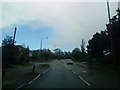
2
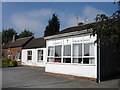
Trowell NG9, Notts
A view, on a dull winter's afternoon, of the A609 road as it leaves its Nottingham end and moves towards its Ilkeston Road section. Behind the low brick wall is the car park belonging to St Helen's Church church hall and beyond the van is a private house that was "The Ring-O-Bells" pub between 1784-1913. Behind the former pub are several shops in a small 1950s shopping parade that once housed a Co-operative Wholesale Society shop.
Image: © David Hallam-Jones
Taken: 31 Jan 2013
0.02 miles
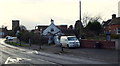
3
Trowell NG9, Notts
The A609 road, looking in the direction of Nottingham. In the past (pre-1970), the main shop in the shopping parade - whose forecourt is visible here - was a Co-op shop. The white-painted property beyond it, now a private house, was "The Ring-o-Bells" pub between 1784-1913.
Image: © David Hallam-Jones
Taken: 31 Jan 2013
0.03 miles
4
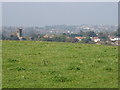
Trowell Vista
The row of houses in the middle distance, terminated by the tower of St Helen's [http://www.geograph.org.uk/photo/982077] on the left, are in the village of Trowell; the buildings in the distance are part of Ilkeston.
Image: © Oxymoron
Taken: 27 Sep 2008
0.03 miles
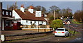
6
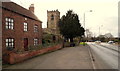
Trowell NG9, Notts
With Wollaton a 20 minute drive away behind the photographer, this is a view of Nottingham Road (the A609) as it follows a right-angled turn and heads towards Ilkeston. The white car at the midpoint of the junction is about to join the A6007, behind St Helen's Church. This is Stapleford Road that ultimately leads to the Bramcote area of Nottingham. Wilnefield House, the large brick built house on the left dates from 1650 and once functioned as the rectory or vicarage for St Helen's Church. According to its owner it has been greatly extended over the years.
Image: © David Hallam-Jones
Taken: 31 Jan 2013
0.06 miles
7
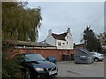
Trowell at twilight (b)
Looking across from the car park at The Festival to the Church Farm Guest House.
Image: © Basher Eyre
Taken: 23 Nov 2011
0.07 miles
8
Trowell: Nottingham Road
Looking towards the parish church on a fine October morning.
Image: © John Sutton
Taken: 14 Oct 2017
0.07 miles
9
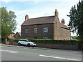
4 Nottingham Road, Trowell
Former farmhouse, late 18th century, Listed Grade II.
Image: © Alan Murray-Rust
Taken: 9 Aug 2021
0.07 miles
10
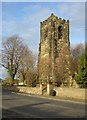
Trowell Church tower
This stately tower stands up well above the village. Dedicated to St Helen, the church dates from the 13th to 15th centuries but shows plenty of evidence of the typical Victorian restoration.
Image: © Alan Murray-Rust
Taken: 11 Nov 2007
0.07 miles