IMAGES TAKEN NEAR TO
Lyndale Road, NOTTINGHAM, NG9 3LB
Introduction
This page details the photographs taken nearby to Lyndale Road, NG9 3LB by members of the Geograph project.
The Geograph project started in 2005 with the aim of publishing, organising and preserving representative images for every square kilometre of Great Britain, Ireland and the Isle of Man.

There are currently over 7.5m images from over14,400 individuals and you can help contribute to the project by visiting https://www.geograph.org.uk
Image Map
Images are licensed for reuse under creativecommons.org/licenses/by-sa/2.0
Notes
- Clicking on the map will re-center to the selected point.
- The higher the marker number, the further away the image location is from the centre of the postcode.
Image Listing (62 Images Found)
Images are licensed for reuse under creativecommons.org/licenses/by-sa/2.0
Image
Details
Distance
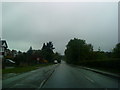
2
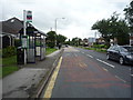
Ilkeston Road
Ilkeston Road or the A6007 is a busy road running through Nottingham suburbs.
Image: © Malcolm Neal
Taken: 18 Nov 2021
0.08 miles
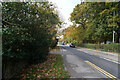
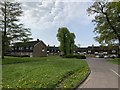
3
Bramcote Post Office
Separated from the main area of the village by the A52.
Image: © David Lally
Taken: 29 Jan 2008
0.11 miles
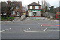
5
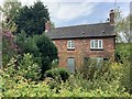
Farm Cottage, Stapleford
Awaiting new owners.
Image: © Andrew Abbott
Taken: 26 Apr 2020
0.12 miles
8
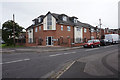
Oakland Court, Stapleford
A housing development of the late 1960s or early 1970s.
Image: © Andrew Abbott
Taken: 26 Apr 2020
0.13 miles
9
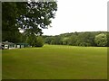
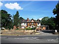
Bramcote Cricket Club
Now well established within Bramcote Hills Park, although it probably did not occupy this space when founded in 1858.
Image: © Alan Murray-Rust
Taken: 9 Aug 2021
0.13 miles