IMAGES TAKEN NEAR TO
Coventry Lane, NOTTINGHAM, NG9 3GG
Introduction
This page details the photographs taken nearby to Coventry Lane, NG9 3GG by members of the Geograph project.
The Geograph project started in 2005 with the aim of publishing, organising and preserving representative images for every square kilometre of Great Britain, Ireland and the Isle of Man.

There are currently over 7.5m images from over14,400 individuals and you can help contribute to the project by visiting https://www.geograph.org.uk
Image Map
Images are licensed for reuse under creativecommons.org/licenses/by-sa/2.0
Notes
- Clicking on the map will re-center to the selected point.
- The higher the marker number, the further away the image location is from the centre of the postcode.
Image Listing (65 Images Found)
Images are licensed for reuse under creativecommons.org/licenses/by-sa/2.0
Image
Details
Distance
1
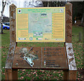
Information Board for Bramcote Hills Park
Utilising the same design as Attenborough Nature Reserve. http://www.geograph.org.uk/photo/678956
Image: © David Lally
Taken: 11 Jan 2009
0.04 miles
2
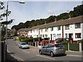
Longden Close, Stapleford
The trees in the background clothe the hill on which the Hemlock stone sits [http://www.geograph.org.uk/photo/622248].
Image: © Oxymoron
Taken: 15 Aug 2008
0.05 miles
3
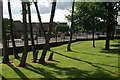
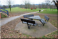
Bramcote Hills Park
A corner of this 27-hectare park, with the junction between Ilkeston Road and Coventry Lane just outside the boundary fence.
Image: © Stephen McKay
Taken: 18 Aug 2012
0.05 miles
5
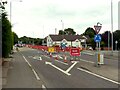
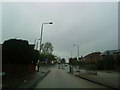
Ilkeston Road closure, Stapleford
A significant closure with substantial diversions while Severn Trent make 'new connections'. The closure notices do not state whether this is for water supply or sewerage.
Image: © Alan Murray-Rust
Taken: 9 Aug 2021
0.06 miles
7
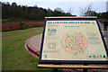
Information Board for the Sundial Maze
In Bromcote Hills Park.
Image: © David Lally
Taken: 11 Jan 2009
0.07 miles
8
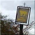
The sign of The Jaguar
In a poor state, but not as poor as the pub Image
Image: © David Lally
Taken: 12 Apr 2014
0.08 miles
9
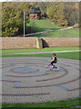
Not in working order
This is the Sundial Maze in the Bramcote Hills Walled Garden. The idea is that if you stand in the centre, your shadow will point to the correct time. Unfortunately even at midday, the late November sun does not fall on the dial. It is laid out as a maze with the red brick lines and the hour markers actings as no-go marks.
In the distance is the Hemlock Stone Image
Image: © Alan Murray-Rust
Taken: 25 Nov 2007
0.09 miles
10

Bramcote Hills Park
This 27 hectare park is effectively all that divides Stapleford from the west Nottingham suburbs. It is owned by Broxtowe Borough Council.
Image: © Stephen McKay
Taken: 18 Aug 2012
0.09 miles