IMAGES TAKEN NEAR TO
Chilwell Lane, NOTTINGHAM, NG9 3DS
Introduction
This page details the photographs taken nearby to Chilwell Lane, NG9 3DS by members of the Geograph project.
The Geograph project started in 2005 with the aim of publishing, organising and preserving representative images for every square kilometre of Great Britain, Ireland and the Isle of Man.

There are currently over 7.5m images from over14,400 individuals and you can help contribute to the project by visiting https://www.geograph.org.uk
Image Map
Images are licensed for reuse under creativecommons.org/licenses/by-sa/2.0
Notes
- Clicking on the map will re-center to the selected point.
- The higher the marker number, the further away the image location is from the centre of the postcode.
Image Listing (99 Images Found)
Images are licensed for reuse under creativecommons.org/licenses/by-sa/2.0
Image
Details
Distance
1
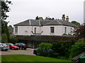
St. John's College, Bramcote
A theological college with Evangelical tendencies.
Image: © Andrew Abbott
Taken: 28 Mar 2010
0.01 miles
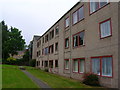
2
St John's College
An Anglican theological college training men and women for Christian ministry and service. This is the view from Peache Way.
Image: © Alan Murray-Rust
Taken: 6 Sep 2009
0.02 miles
3
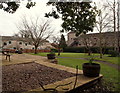
St John's College, Bramcote NG9, Notts.
A garden plot off Peache Way seen through a wrought-iron gate set into a "listed" boundary wall. This apron-shaped plot is bordered on three sides by some of the residential accommodation owned by St John's (Anglican) Theological College. The raised area on the left is the site of a former Orangery. The college's main educational premises occupy a large Grade II-listed house built in 1810 that was originally known as Grove House.
Image: © David Hallam-Jones
Taken: 21 Mar 2013
0.03 miles
4
St John's College, Bramcote NG9, Notts.
A garden plot and a Grade II-listed boundary wall off Peache Way. This plot is bordered on three sides by some of the residential accommodation occupied by St John's (Anglican) Theological College students. The raised area in front of the red-brick wall is the site of a former Orangery. The college's main educational premises (not visible here) occupy a large Grade II-listed house built in 1810 that was originally known as Grove House.
Image: © David Hallam-Jones
Taken: 21 Mar 2013
0.03 miles
5
St John's College
A Church of England Theological College.
Image: © John H Darch
Taken: 14 May 2009
0.03 miles
6
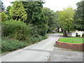
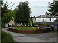
Peache Way
Part of the traditional network of footpaths and byways between Bramcote and Beeston, now surrounded by residential development.
Image: © Alan Murray-Rust
Taken: 6 Sep 2009
0.04 miles
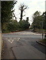
8
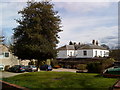
Bramcote NG9, Notts.
With the outskirts of Chilwell behind the photographer, this is a view of Chilwell Lane as it heads towards a cutting made years ago to allow the road to cut through Bramcote and to reach the road between Nottingham and Derby, now "Derby Road (the A52)". Immediately before the commencement of the cutting Peache Way branches off to the right and Common Lane to the left. The elevated plot of land opposite the bus stop is one corner of the former Grove House estate (c.1810) that is now occupied by St John's (Anglican) Theoogical College. The college Reception is reached via Peache Way.
Image: © David Hallam-Jones
Taken: 21 Mar 2013
0.05 miles
9
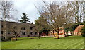
Bramcote NG9, Notts.
This is a view from Common Lane, 99% of which lies behind the photographer. Peache Way lies opposite. These two roads are separated by Chilwell Lane that connects Chilwell (on the right) and Bramcote village (on the left). Peache Way, a cul-de-sac, is lined on one side by privately owned residential properties and on the other side by premises belonging to St John's (Anglican) Theological College, including its Reception.
Image: © David Hallam-Jones
Taken: 21 Mar 2013
0.06 miles
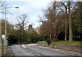
10
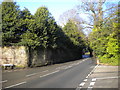
Chilwell Lane, Bramcote
Seen from the end of Peache Way (right), north of which Chilwell Lane narrows, with sheer walls on either side, before becoming Town Street and going through a very sharp S bend. This road is used by TrentBarton bus route 18, which runs twice an hour during the day; careful manoeuvring is required when two buses meet on the bend.
Image: © Richard Vince
Taken: 8 Feb 2014
0.06 miles