IMAGES TAKEN NEAR TO
Court Yard, NOTTINGHAM, NG9 3DL
Introduction
This page details the photographs taken nearby to Court Yard, NG9 3DL by members of the Geograph project.
The Geograph project started in 2005 with the aim of publishing, organising and preserving representative images for every square kilometre of Great Britain, Ireland and the Isle of Man.

There are currently over 7.5m images from over14,400 individuals and you can help contribute to the project by visiting https://www.geograph.org.uk
Image Map
Images are licensed for reuse under creativecommons.org/licenses/by-sa/2.0
Notes
- Clicking on the map will re-center to the selected point.
- The higher the marker number, the further away the image location is from the centre of the postcode.
Image Listing (121 Images Found)
Images are licensed for reuse under creativecommons.org/licenses/by-sa/2.0
Image
Details
Distance
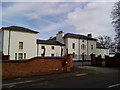
1
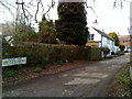
Court Yard, Bramcote
Court Yard in Bramcote
Image: © Andrew Abbott
Taken: 28 Mar 2010
0.02 miles
2
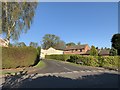
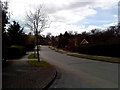
Grangelea Gardens
From Claremont Avenue.
Image: © Andrew Abbott
Taken: 16 Apr 2020
0.06 miles
3
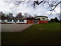
Primary School, Bramcote
A primary school on Cow Lane, Bramcote
Image: © Andrew Abbott
Taken: 28 Mar 2010
0.07 miles
4
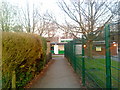
Gitty between Hanley Avenue and Bridle Road, Bramcote
Image: © Andrew Abbott
Taken: 16 Apr 2010
0.07 miles
5
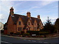
Bramcote Almshouses
Almshouses in Bramcote erected in 1852 by Frances Jane Longden.
Image: © Andrew Abbott
Taken: 28 Mar 2010
0.07 miles
6
The Almshouses, Bramcote
Date from 1852 https://historicengland.org.uk/listing/the-list/list-entry/1263871?section=official-list-entry
Image: © Jonathan Thacker
Taken: 13 Apr 2022
0.08 miles
7
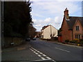
Town Street, Bramcote
Town Street, Bramcote looking north west from the junction with Cow Lane.
Image: © Andrew Abbott
Taken: 28 Mar 2010
0.08 miles
8
Claremont Avenue, Bramcote
A view of Claremont Avenue, Bramcote
Image: © Andrew Abbott
Taken: 28 Mar 2010
0.08 miles
9
The Grange, Bramcote
The Grange, Bramcote, on Town Street.
Image: © Andrew Abbott
Taken: 28 Mar 2010
0.09 miles
10
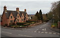
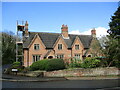
Bramcote NG9, Notts.
A view from the elevated graveyard of the former 14th century parish church situated obliquely opposite these Grade II-listed almshouses. Ahead is Cow Lane, sloping eastwards towards the Bramcote Hills area, where it connects with the A52 (a.k.a. Derby Road and Brian Clough Way). These four homes were constructed in 1852 courtesy of an endowment left by Frances Jane Longden, the sister of John Sherwin Gregory, a previous owner of the former Bramcote Manor. The latter was demolished in 1960. The almshouses were renovated and modernised in 1984-5 with the aid of a grant from Broxtowe Borough Council. Cow Lane appears on Chapman's map of 1774.
Image: © David Hallam-Jones
Taken: 21 Mar 2013
0.09 miles