IMAGES TAKEN NEAR TO
Heather Rise, NOTTINGHAM, NG9 3AG
Introduction
This page details the photographs taken nearby to Heather Rise, NG9 3AG by members of the Geograph project.
The Geograph project started in 2005 with the aim of publishing, organising and preserving representative images for every square kilometre of Great Britain, Ireland and the Isle of Man.

There are currently over 7.5m images from over14,400 individuals and you can help contribute to the project by visiting https://www.geograph.org.uk
Image Map
Images are licensed for reuse under creativecommons.org/licenses/by-sa/2.0
Notes
- Clicking on the map will re-center to the selected point.
- The higher the marker number, the further away the image location is from the centre of the postcode.
Image Listing (45 Images Found)
Images are licensed for reuse under creativecommons.org/licenses/by-sa/2.0
Image
Details
Distance
1
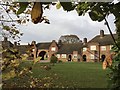
Abel Collins almshouses
Moved here from Nottingham city centre in the 1950s
Image: © Andrew Abbott
Taken: 13 Nov 2016
0.09 miles
2
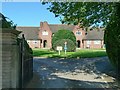
Abel Collin's almshouses, main entrance
Almshouses in central Nottingham were set up under the will of Able Collin who died in 1705. Redevelopment in the city resulted in the move to the Derby Road site in the late 1930s, when this part of the building was erected, comprising 26 units. With the demolition of the final city almshouses, further units were built, and there have been additional units built in recent years. In total there are currently 63 dwellings on the site, which must make it one of the largest groups of almshouses in the UK. See http://www.abelcollins.org.uk/history.htm
Image: © Alan Murray-Rust
Taken: 18 Sep 2016
0.09 miles
3
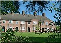
Abel Collin's almshouses, east wing
Part of the original buildings, dating from c.1938. See http://www.geograph.org.uk/photo/5123223 for more information.
Image: © Alan Murray-Rust
Taken: 18 Sep 2016
0.10 miles
4
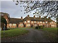
Abel Collins almshouses
Moved here in the 1950s from Nottingham city centre
Image: © Andrew Abbott
Taken: 13 Nov 2016
0.10 miles
5
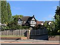
42 Derby Road, Beeston
Detached house dating from 1929-30 by the architect G.E. King. Contractor J. Brough.
Image: © Andrew Abbott
Taken: 6 May 2020
0.12 miles
6
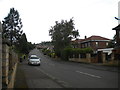
David Grove, Beeston
Seen from its junction with Derby Road.
Image: © Richard Vince
Taken: 7 Jul 2012
0.12 miles
7
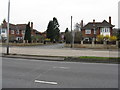
Carwood Road
Looking across the Derby Road [A52] from the Nurseryman pub.
Image: © M J Richardson
Taken: 3 Mar 2011
0.12 miles
8
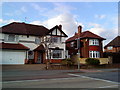
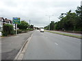
A52 in Beeston
Houses on the A52 in Beeston.
Image: © Andrew Abbott
Taken: 27 Mar 2010
0.13 miles
10
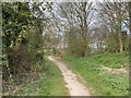
Track on Bramcote Hills
Looking north.
Image: © Andrew Abbott
Taken: 29 Mar 2020
0.13 miles