IMAGES TAKEN NEAR TO
Lawley Avenue, NOTTINGHAM, NG9 2SL
Introduction
This page details the photographs taken nearby to Lawley Avenue, NG9 2SL by members of the Geograph project.
The Geograph project started in 2005 with the aim of publishing, organising and preserving representative images for every square kilometre of Great Britain, Ireland and the Isle of Man.

There are currently over 7.5m images from over14,400 individuals and you can help contribute to the project by visiting https://www.geograph.org.uk
Image Map
Images are licensed for reuse under creativecommons.org/licenses/by-sa/2.0
Notes
- Clicking on the map will re-center to the selected point.
- The higher the marker number, the further away the image location is from the centre of the postcode.
Image Listing (81 Images Found)
Images are licensed for reuse under creativecommons.org/licenses/by-sa/2.0
Image
Details
Distance
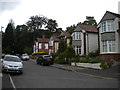
1
Baslow Drive, Lenton Abbey estate
A narrow residential road from the days when there were fewer cars to accommodate.
Image: © Richard Vince
Taken: 11 Jun 2013
0.03 miles
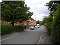
2
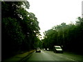
Charles Avenue from Derby Road
Inter-war housing development within the former Lenton Park.
Image: © Alan Murray-Rust
Taken: 9 Feb 2014
0.03 miles
3

Houses on Charles Avenue
Adjacent to the Lenton Abbey Estate.
Image: © Andrew Abbott
Taken: 22 May 2020
0.03 miles
4
Charles Avenue, Lenton Abbey
A residential cul de sac, connected to the outside world only via Derby Road (just beyond the bend in the distance).
Image: © Richard Vince
Taken: 11 Jun 2013
0.03 miles
5
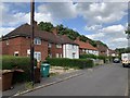
Houses on Baslow Drive, Beeston
Part of the Lenton Abbey Estate.
Image: © Andrew Abbott
Taken: 22 May 2020
0.03 miles

8
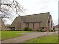
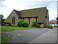
St Barnabas's Church, Lenton Abbey
Designed by local architect T Cecil Howitt to serve the residents of the recently developed Lenton Abbey council estate. Although contemporary with his nearby St Mary's Church, Wollaton Park http://www.geograph.org.uk/photo/3844259 the architectural style is noticeably different. St Barnabas was opened on 28 June, 1938, originally as a chapel of ease to Holy Trinity, Lenton, but becoming a parish in its own right in 1955.
Image: © Alan Murray-Rust
Taken: 9 Feb 2014
0.05 miles
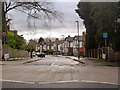
10
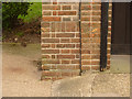
Bench mark, St Barnabas's Church, Lenton Abbey
Situated just to the left of the main door at the north west corner of the church. See http://www.geograph.org.uk/photo/3845598 for location.
Image: © Alan Murray-Rust
Taken: 9 Feb 2014
0.06 miles