IMAGES TAKEN NEAR TO
High Road, NOTTINGHAM, NG9 2LN
Introduction
This page details the photographs taken nearby to High Road, NG9 2LN by members of the Geograph project.
The Geograph project started in 2005 with the aim of publishing, organising and preserving representative images for every square kilometre of Great Britain, Ireland and the Isle of Man.

There are currently over 7.5m images from over14,400 individuals and you can help contribute to the project by visiting https://www.geograph.org.uk
Image Map
Images are licensed for reuse under creativecommons.org/licenses/by-sa/2.0
Notes
- Clicking on the map will re-center to the selected point.
- The higher the marker number, the further away the image location is from the centre of the postcode.
Image Listing (716 Images Found)
Images are licensed for reuse under creativecommons.org/licenses/by-sa/2.0
Image
Details
Distance
1
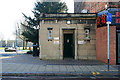
Public Toilet on High Road, Beeston
Until the refurbishment of the entrance to the Broadgate Recreation Ground (seen on the left) This was one of a pair of conveniences which stood at each side of some quite impressive gates. The other toilet and the gates were swept-away.
I can't remember if these were the Ladies or the Gents.
Image: © David Lally
Taken: 4 Feb 2009
0.00 miles
2
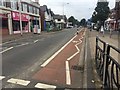
Bicycle contraflow
Along a one-way section of Broadgate. An example of 1990s cycling infrastructure which has stood the test of time.
Image: © David Lally
Taken: 21 Sep 2016
0.01 miles
3
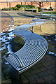
S-Shaped Bench
The entrance to this small open space to the south of the west-end of Beeston High Road was re-vamped a couple of years ago.
Image: © David Lally
Taken: 4 Feb 2009
0.01 miles
4
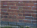
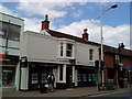
Bench mark, #111 High Road, Beeston
See http://www.geograph.org.uk/photo/3816840 for location. The mark has been highlighted with yellow road-marker.
Image: © Alan Murray-Rust
Taken: 13 Jan 2014
0.01 miles
5
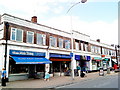
Home Made Bakery, High Road, Beeston
One hopes that it is the bread rather than the bakery that is home made.
There is a bench mark http://www.geograph.org.uk/photo/3816839 on the side wall.
Image: © Alan Murray-Rust
Taken: 13 Jan 2014
0.01 miles
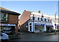
7
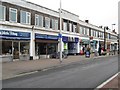
Row of Shops
With an Art-Deco feel.
This row is on the edge of the shopping area of Beeston. Just a few yards further and High Road becomes Broadgate.
Image: © David Lally
Taken: 12 Feb 2009
0.02 miles
9
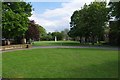
Broadgate Park, High Road, Beeston, Nottingham
A public park since 1923. In the far distance is the Beeston Boer War Memorial.
Image
Image: © P L Chadwick
Taken: 11 May 2019
0.02 miles
10
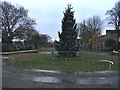
Beeston Christmas tree 2016
The siting of the tree here in Broadgate Park instead of in The Square http://www.geograph.org.uk/photo/4777970 as usual has caused some controversy. The Council's reason it to allow more space for market stalls in December in that location.
Image: © David Lally
Taken: 7 Dec 2016
0.02 miles