IMAGES TAKEN NEAR TO
Queens Road East, NOTTINGHAM, NG9 2LD
Introduction
This page details the photographs taken nearby to Queens Road East, NG9 2LD by members of the Geograph project.
The Geograph project started in 2005 with the aim of publishing, organising and preserving representative images for every square kilometre of Great Britain, Ireland and the Isle of Man.

There are currently over 7.5m images from over14,400 individuals and you can help contribute to the project by visiting https://www.geograph.org.uk
Image Map
Images are licensed for reuse under creativecommons.org/licenses/by-sa/2.0
Notes
- Clicking on the map will re-center to the selected point.
- The higher the marker number, the further away the image location is from the centre of the postcode.
Image Listing (291 Images Found)
Images are licensed for reuse under creativecommons.org/licenses/by-sa/2.0
Image
Details
Distance
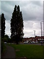
1
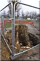
Poplar stump awaits removal
At the end of Queens Road at the junction with University Boulevard. Making way for NET Phase 2. The trunk as it was (from the other side) is here Image
Image: © David Lally
Taken: 8 Apr 2013
0.01 miles
2
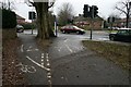
Cycle path markings
The cycle lane comes to the end of University Boulevard.
Image: © David Lally
Taken: 19 Jan 2010
0.02 miles
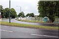
3
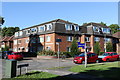
Serina Court
Tattershall Drive, Beeston
Image: © Andrew Abbott
Taken: 29 Aug 2016
0.02 miles
4
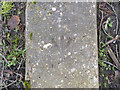
Rivet bench mark alongside Queens Road
See http://www.geograph.org.uk/photo/3837150 for location.
Image: © Alan Murray-Rust
Taken: 2 Feb 2014
0.02 miles
6
University Boulevard tram stop
The rails are now in place.
Image: © Alan Murray-Rust
Taken: 4 Apr 2014
0.03 miles
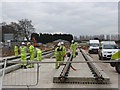
7
Services work at Queens Road junction (1)
This is the site of the University Boulevard tram stop, looking east.
Image: © Alan Murray-Rust
Taken: 21 Jun 2012
0.03 miles
8
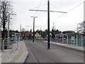
University Boulevard tram stop
Now largely complete; some finishing-off required around poles, and the ticket machines not yet installed.
Image: © Alan Murray-Rust
Taken: 13 Jan 2015
0.03 miles
9
Cycle lane and path
At the end of Lower Road. Here showing no sign of the NET tram work to come.
Image: © David Lally
Taken: 10 May 2012
0.03 miles
10
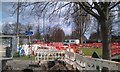
NET plastic barriers
Surrounding the work going on at the end of Lower Road.
Compare with Image
Image: © David Lally
Taken: 16 Apr 2013
0.03 miles