IMAGES TAKEN NEAR TO
Abbey Road, NOTTINGHAM, NG9 2HP
Introduction
This page details the photographs taken nearby to Abbey Road, NG9 2HP by members of the Geograph project.
The Geograph project started in 2005 with the aim of publishing, organising and preserving representative images for every square kilometre of Great Britain, Ireland and the Isle of Man.

There are currently over 7.5m images from over14,400 individuals and you can help contribute to the project by visiting https://www.geograph.org.uk
Image Map
Images are licensed for reuse under creativecommons.org/licenses/by-sa/2.0
Notes
- Clicking on the map will re-center to the selected point.
- The higher the marker number, the further away the image location is from the centre of the postcode.
Image Listing (62 Images Found)
Images are licensed for reuse under creativecommons.org/licenses/by-sa/2.0
Image
Details
Distance
1
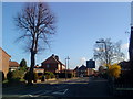
Abbey Road, Beeston
From the junction with Marlborough Road.
Image: © Andrew Abbott
Taken: 26 Mar 2010
0.05 miles
2
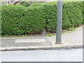
Boundary marker, Wensor Avenue
One of a pair of markers either side of the road, see also http://www.geograph.org.uk/photo/3920786
Image: © Alan Murray-Rust
Taken: 4 Apr 2014
0.05 miles
3
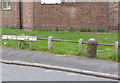
Boundary marker, Wensor Avenue
One of a pair of markers either side of the road, see also http://www.geograph.org.uk/photo/3920782
Image: © Alan Murray-Rust
Taken: 4 Apr 2014
0.06 miles
4
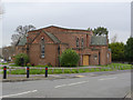
Beeston United Reformed Church
Originally a Congregational Church. Some of the brickwork patterns and the glazed tiles are typical of the Art Deco period.
Image: © Alan Murray-Rust
Taken: 4 Apr 2014
0.07 miles
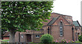
5
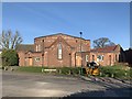
Boundary Road United Reformed Church
Lenton Abbey Congregational Church congregation formed in 1929. Church opened in 1933. Later renamed Boundary Road United Reformed Church. Closed 2010.
Image: © Andrew Abbott
Taken: 25 Mar 2020
0.07 miles
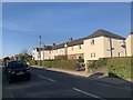
6
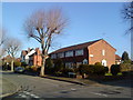
Marlborough Road, Beeston
Houses at the junction of Abbey Road and Marlborough Road, Beeston.
Image: © Andrew Abbott
Taken: 26 Mar 2010
0.07 miles
7
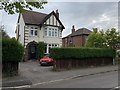
100 Marlborough Road, Beeston
Architect C.E. Allsop 1925
Image: © Andrew Abbott
Taken: 18 May 2020
0.07 miles
8
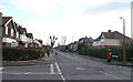
Marlborough Road, Beeston
Seen here from its junction with Clifford Avenue (Image) and Hetley Road (crossing from left to right), Marlborough Road has an interesting mix of house types and designs. The London Plane trees with which it is lined were severely pollarded last winter.
Image: © David Lally
Taken: 30 Jan 2008
0.07 miles
9
United Reformed Church, Beeston
Viewed from Boundary Road.
Image: © Oxymoron
Taken: 5 Aug 2008
0.08 miles
10
6-12 Heeley Road, Beeston
A row of terraced houses
Image: © Andrew Abbott
Taken: 25 Mar 2020
0.08 miles