IMAGES TAKEN NEAR TO
Manton Crescent, NOTTINGHAM, NG9 2GA
Introduction
This page details the photographs taken nearby to Manton Crescent, NG9 2GA by members of the Geograph project.
The Geograph project started in 2005 with the aim of publishing, organising and preserving representative images for every square kilometre of Great Britain, Ireland and the Isle of Man.

There are currently over 7.5m images from over14,400 individuals and you can help contribute to the project by visiting https://www.geograph.org.uk
Image Map
Images are licensed for reuse under creativecommons.org/licenses/by-sa/2.0
Notes
- Clicking on the map will re-center to the selected point.
- The higher the marker number, the further away the image location is from the centre of the postcode.
Image Listing (58 Images Found)
Images are licensed for reuse under creativecommons.org/licenses/by-sa/2.0
Image
Details
Distance
1
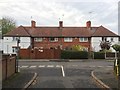
Houses on Manton Crescent
Dating from the 1930s.
Image: © Andrew Abbott
Taken: 13 Nov 2016
0.04 miles

3
Woodside Road, Lenton Abbey
Looking towards the roundabout at the junction with Broadgate and the university west entrance.
Image: © David Lally
Taken: 2 Oct 2009
0.08 miles
4
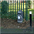
City of Nottingham boundary post
One of the series of cast iron boundary marks erected by the City for the big expansion in the Wollaton area in 1933. This is at the top of Salthouse Lane.
Image: © Alan Murray-Rust
Taken: 13 Jan 2014
0.09 miles
5
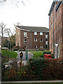
A "Beeston Flat" on Broadgate Park
This area was extensively re-modelled about five years ago. Some of the old Beeston Flats were demolished others like the one in the centre here are now tucked behind the much larger newer buildings.
Image: © David Lally
Taken: 2 Mar 2009
0.10 miles
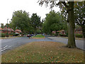
6
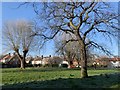
Hathern Green
Pollarded trees on Hathern Green.
Image: © Andrew Abbott
Taken: 26 Mar 2020
0.12 miles
8

Broadgate flats under construction
Broadgate flats under construction taken from University Boulevard
Image: © Andrew Abbott
Taken: 16 Jan 2004
0.13 miles
9

Beeston Evangelical Free Church
On Salthouse Lane.
Image: © Oxymoron
Taken: 12 Aug 2008
0.15 miles
10

Ancaster Hall - University of Nottingham
An extension built in the last few years (it was here in Spring '04) but maps.live aerial view shows a building site.
Image: © David Lally
Taken: 1 Nov 2007
0.15 miles