IMAGES TAKEN NEAR TO
Princess Avenue, NOTTINGHAM, NG9 2DH
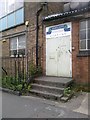
Introduction
This page details the photographs taken nearby to Princess Avenue, NG9 2DH by members of the Geograph project.
The Geograph project started in 2005 with the aim of publishing, organising and preserving representative images for every square kilometre of Great Britain, Ireland and the Isle of Man.

There are currently over 7.5m images from over14,400 individuals and you can help contribute to the project by visiting https://www.geograph.org.uk
Image Map
Images are licensed for reuse under creativecommons.org/licenses/by-sa/2.0
Notes
- Clicking on the map will re-center to the selected point.
- The higher the marker number, the further away the image location is from the centre of the postcode.
Image Listing (563 Images Found)
Images are licensed for reuse under creativecommons.org/licenses/by-sa/2.0
Image
Details
Distance
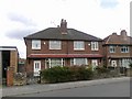
1
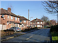
Princess Avenue, Beeston
Typical inter-war semi-detached development.
Image: © Alan Murray-Rust
Taken: 13 Jan 2014
0.01 miles
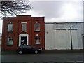
2
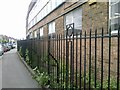
Factory railings on Lower Regent Street
Image: © Andrew Abbott
Taken: 15 Jun 2010
0.03 miles
4
Factory entrance on Lower Regent Street
Image: © Andrew Abbott
Taken: 15 Jun 2010
0.04 miles
5
Burgass Carrier Bags, Beeston
Factory for Burgass Carrier Bags.
Image: © Andrew Abbott
Taken: 22 Mar 2010
0.05 miles
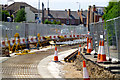
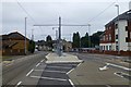
7
The view from Middle Street tram stop
Looking across the tram stop to the businesses by the line.
Image: © Malcolm Neal
Taken: 24 Nov 2021
0.06 miles
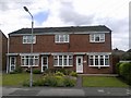
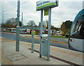
9
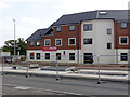
Des Res for students
New student accommodation on the site of the former Three Horseshoes pub, very convenient for the new tramway.
Image: © Alan Murray-Rust
Taken: 22 Sep 2014
0.06 miles