IMAGES TAKEN NEAR TO
Riverside Road, NOTTINGHAM, NG9 1NA
Introduction
This page details the photographs taken nearby to Riverside Road, NG9 1NA by members of the Geograph project.
The Geograph project started in 2005 with the aim of publishing, organising and preserving representative images for every square kilometre of Great Britain, Ireland and the Isle of Man.

There are currently over 7.5m images from over14,400 individuals and you can help contribute to the project by visiting https://www.geograph.org.uk
Image Map
Images are licensed for reuse under creativecommons.org/licenses/by-sa/2.0
Notes
- Clicking on the map will re-center to the selected point.
- The higher the marker number, the further away the image location is from the centre of the postcode.
Image Listing (353 Images Found)
Images are licensed for reuse under creativecommons.org/licenses/by-sa/2.0
Image
Details
Distance
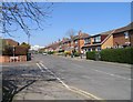
4
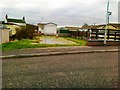
South Road, Beeston Rylands
Houses from the 1920s.
Image: © Andrew Abbott
Taken: 29 Aug 2016
0.02 miles
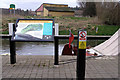
5
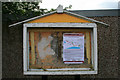
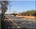
Notice board on Riverside Road
Doesn't look like it is used much now, but is being utilised for an Environment Agency notice about the current flood defence work.
Image: © David Lally
Taken: 17 May 2010
0.02 miles
7
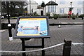
Information board, Beeston Lock
With the lock cottage behind.
Image: © David Lally
Taken: 10 Mar 2008
0.03 miles
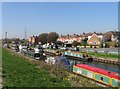
8
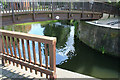
Footbridge by Beeston Lock
The lock is to the right with the Beeston Canal stretching off to the left.
Ahead showing under the bridge is a short stub (with gates) large enough for about four narrow boats. The visible part of this stub effectively forms a small basin in which boats not wishing to carry on onto the Trent can turn, to return down the canal.
Image: © David Lally
Taken: 15 Aug 2008
0.03 miles
10
Information board, Beeston Waterfront
The Weir Fields sports pavilion in the background.
Image: © David Lally
Taken: 10 Mar 2008
0.03 miles