IMAGES TAKEN NEAR TO
Chilwell Road, NOTTINGHAM, NG9 1FW
Introduction
This page details the photographs taken nearby to Chilwell Road, NG9 1FW by members of the Geograph project.
The Geograph project started in 2005 with the aim of publishing, organising and preserving representative images for every square kilometre of Great Britain, Ireland and the Isle of Man.

There are currently over 7.5m images from over14,400 individuals and you can help contribute to the project by visiting https://www.geograph.org.uk
Image Map
Images are licensed for reuse under creativecommons.org/licenses/by-sa/2.0
Notes
- Clicking on the map will re-center to the selected point.
- The higher the marker number, the further away the image location is from the centre of the postcode.
Image Listing (1232 Images Found)
Images are licensed for reuse under creativecommons.org/licenses/by-sa/2.0
Image
Details
Distance
1
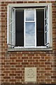
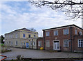
Date stone and window
On the extension to the old Beeston police station which is now being demolished. See Image
Image: © David Lally
Taken: 4 Aug 2016
0.01 miles
2
More of the former Beeston Police Station is demolished
See also Image
Image: © David Lally
Taken: 8 Aug 2016
0.01 miles
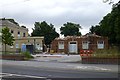
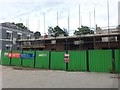
3
Demolition is complete
And the rubble cleared Image Obviously not viewed as a contaminated site so the building remains have been removed straight away.
Image: © David Lally
Taken: 23 Aug 2016
0.01 miles
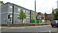
4
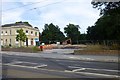
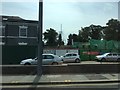
New apartments being built
Chilwell Road next to The Grange (on the left of the picture).
Image: © David Lally
Taken: 1 Feb 2018
0.01 miles
6
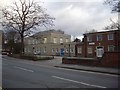
Former Police Station
In June 2013 local policing moved into a shared resources building on Foster Avenue owned by Broxtowe Borough Council.
The old Police Station is currently for sale for redevelopment. Prospective users will be influenced by the fact that the further part of the building, originally The Grange, is Listed Grade II and therefore subject to planning restrictions.
Image: © Alan Murray-Rust
Taken: 22 Dec 2013
0.01 miles
7
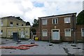
Partial demolition of the former Beeston police station
At least I assume it's just the 1950s extension on the right that is going as the original house on the left (The Grange) has a Grade II listing https://historicengland.org.uk/listing/the-list/list-entry/1247918 .
Image: © David Lally
Taken: 4 Aug 2016
0.01 miles
8
Building new apartments
Next to the Grange and where the 1950's police station extension was.
Image: © David Lally
Taken: 6 Jul 2017
0.01 miles
9
Building new apartments
Next to the Grange and where the 1950's police station extension was.
Image: © David Lally
Taken: 27 Jul 2017
0.01 miles
10
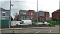
The Grange and new apartment block
Still no one has moved into the apartments in the refurbished Grange. And the new-build block is still not complete.
The Grange was the Beeston Police Station for many years Image and is Grade II listed.
List entry Number: 1247918 https://www.historicengland.org.uk/listing/the-list/list-entry/1247918
Image: © David Lally
Taken: 4 May 2018
0.01 miles