IMAGES TAKEN NEAR TO
Mellors Way, Nottingham Business Park, NOTTINGHAM, NG8 6PY
Introduction
This page details the photographs taken nearby to Mellors Way, Nottingham Business Park, NG8 6PY by members of the Geograph project.
The Geograph project started in 2005 with the aim of publishing, organising and preserving representative images for every square kilometre of Great Britain, Ireland and the Isle of Man.

There are currently over 7.5m images from over14,400 individuals and you can help contribute to the project by visiting https://www.geograph.org.uk
Image Map
Images are licensed for reuse under creativecommons.org/licenses/by-sa/2.0
Notes
- Clicking on the map will re-center to the selected point.
- The higher the marker number, the further away the image location is from the centre of the postcode.
Image Listing (29 Images Found)
Images are licensed for reuse under creativecommons.org/licenses/by-sa/2.0
Image
Details
Distance
1
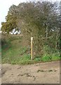
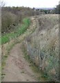
Footpath at Chilwell Dam
Although not shown on the OS maps as a right of way, this path is clearly waymarked as such. Note the older sign almost hidden in the hedge.
Image: © Alan Murray-Rust
Taken: 11 Nov 2007
0.07 miles
2
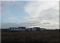
Nottingham Business Park seen from the north west
The business park has been developed on the site of the former Chilwell Dam Farm
Image: © Alan Murray-Rust
Taken: 11 Nov 2007
0.09 miles
3
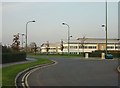
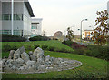
Nottingham Business Park
This is a modern development right on the edge of the City on former farmland
Image: © Alan Murray-Rust
Taken: 4 Nov 2007
0.09 miles
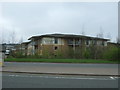
4
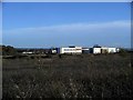
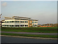
Nottingham Business Park
Nottingham Business Park, built on former farmland, covers an area of 120 acres. The DVLA and the Highways Agency, among others, have offices there. The photo shows the rear of the site, taken from a footpath close to the M1 motorway.
Image: © Lynne Kirton
Taken: 13 Nov 2010
0.10 miles
5
Parallel footpaths
The left hand path is the long-established footpath over to Swingate. As part of the development of the Nottingham Business Park, a second footpath has been established running parallel to it. There is a 2-wire fence between the two paths, already substantially decayed. The new path leads to a light-controlled pedestrian crossing, so presumably the intention was to supersede the older path, although as can be seen this is still very well used.
Image: © Alan Murray-Rust
Taken: 11 Nov 2007
0.10 miles
6
Nottingham Business Park
This is a modern development on former farmland on the edge of the city.
Image: © Alan Murray-Rust
Taken: 4 Nov 2007
0.11 miles
7
Nottingham Business Park
This is a modern development on former farmland on the edge of the city.
Image: © Alan Murray-Rust
Taken: 4 Nov 2007
0.12 miles
8
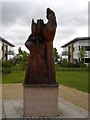
Wooden Statue on Nottingham Business Park
Of two hands clasping a flower, the significance of which I'm unsure.
Image: © Oxymoron
Taken: 6 Aug 2008
0.12 miles
9
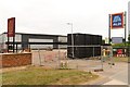
Construction of a new Aldi supermarket, Nottingham Business Park
Image: © Mark Anderson
Taken: 22 Jul 2018
0.12 miles
10
The Nottingham Belfry Hotel
Beside Woodhouse Way (A6002).
Image: © JThomas
Taken: 27 Mar 2017
0.13 miles