IMAGES TAKEN NEAR TO
Cranwell Road, NOTTINGHAM, NG8 6NP
Introduction
This page details the photographs taken nearby to Cranwell Road, NG8 6NP by members of the Geograph project.
The Geograph project started in 2005 with the aim of publishing, organising and preserving representative images for every square kilometre of Great Britain, Ireland and the Isle of Man.

There are currently over 7.5m images from over14,400 individuals and you can help contribute to the project by visiting https://www.geograph.org.uk
Image Map
Images are licensed for reuse under creativecommons.org/licenses/by-sa/2.0
Notes
- Clicking on the map will re-center to the selected point.
- The higher the marker number, the further away the image location is from the centre of the postcode.
Image Listing (7 Images Found)
Images are licensed for reuse under creativecommons.org/licenses/by-sa/2.0
Image
Details
Distance
1
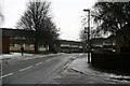
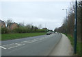
Cranwell Road
On the western edge of the Broxtowe Estate, Nottingham.
The Borough of Broxtowe does not include the district of Broxtowe, it is within the boundaries of the City of Nottingham.
Image: © David Lally
Taken: 15 Jan 2010
0.01 miles
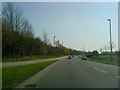
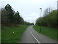
3
Flamsteed Road, Strelley Estate
Situated between two roundabouts, Flamsteed Road provides a convenient terminus for Nottingham City Transport bus routes 77 and 78, which approach from opposite ends. The East Lancs bodied Scania N94UD seen here is waiting to head for the city centre on the latter route, via Aspley estate and Nuthall Road.
Image: © Richard Vince
Taken: 15 Sep 2012
0.20 miles
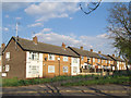
7
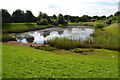
Balance pond for Nottingham Business Park
The balance pond for Nottingham Business Park.
Anglers use this for fishing.
Image: © Richard Horry
Taken: 21 Jun 2014
0.23 miles