IMAGES TAKEN NEAR TO
Flamsteed Road, NOTTINGHAM, NG8 6NB
Introduction
This page details the photographs taken nearby to Flamsteed Road, NG8 6NB by members of the Geograph project.
The Geograph project started in 2005 with the aim of publishing, organising and preserving representative images for every square kilometre of Great Britain, Ireland and the Isle of Man.

There are currently over 7.5m images from over14,400 individuals and you can help contribute to the project by visiting https://www.geograph.org.uk
Image Map
Images are licensed for reuse under creativecommons.org/licenses/by-sa/2.0
Notes
- Clicking on the map will re-center to the selected point.
- The higher the marker number, the further away the image location is from the centre of the postcode.
Image Listing (49 Images Found)
Images are licensed for reuse under creativecommons.org/licenses/by-sa/2.0
Image
Details
Distance
1
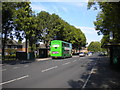
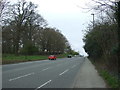
Flamsteed Road, Strelley Estate
Situated between two roundabouts, Flamsteed Road provides a convenient terminus for Nottingham City Transport bus routes 77 and 78, which approach from opposite ends. The East Lancs bodied Scania N94UD seen here is waiting to head for the city centre on the latter route, via Aspley estate and Nuthall Road.
Image: © Richard Vince
Taken: 15 Sep 2012
0.13 miles
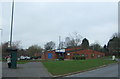
2
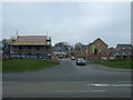
Broxtowe Police Station
A modern replacement for a much smaller unit in the corner of Strelley Recreation Ground, but serving a much wider area of west Nottingham.
Image: © Alan Murray-Rust
Taken: 18 Mar 2014
0.16 miles
4
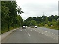
Woodhouse Way
Recreating this 'First' for the square http://www.geograph.org.uk/photo/51194 . The road has been widened at this location to provide for a junction into Woodhouse Park housing development, built between 2015 and 2018.
Image: © Alan Murray-Rust
Taken: 18 Aug 2021
0.16 miles
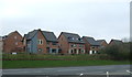
6
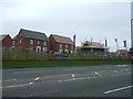
Princess Boulevard
New housing development off Woodhouse Way (A6002).
Image: © JThomas
Taken: 27 Mar 2017
0.16 miles
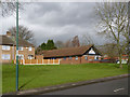
8
Strelley Health Centre
A modern facility on Strelley Road.
Image: © Alan Murray-Rust
Taken: 18 Mar 2014
0.17 miles