IMAGES TAKEN NEAR TO
Strelley Road, NOTTINGHAM, NG8 6LL
Introduction
This page details the photographs taken nearby to Strelley Road, NG8 6LL by members of the Geograph project.
The Geograph project started in 2005 with the aim of publishing, organising and preserving representative images for every square kilometre of Great Britain, Ireland and the Isle of Man.

There are currently over 7.5m images from over14,400 individuals and you can help contribute to the project by visiting https://www.geograph.org.uk
Image Map
Images are licensed for reuse under creativecommons.org/licenses/by-sa/2.0
Notes
- Clicking on the map will re-center to the selected point.
- The higher the marker number, the further away the image location is from the centre of the postcode.
Image Listing (60 Images Found)
Images are licensed for reuse under creativecommons.org/licenses/by-sa/2.0
Image
Details
Distance
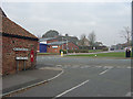
1
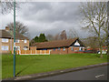
Broxtowe Police Station
A modern replacement for a much smaller unit in the corner of Strelley Recreation Ground, but serving a much wider area of west Nottingham.
Image: © Alan Murray-Rust
Taken: 18 Mar 2014
0.01 miles
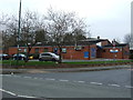
2
Strelley Health Centre
A modern facility on Strelley Road.
Image: © Alan Murray-Rust
Taken: 18 Mar 2014
0.03 miles
5
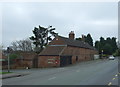
Barn on Strelley Road
Showing position of Postbox No. NG8 308.
See Image] for postbox.
Image: © JThomas
Taken: 27 Mar 2017
0.06 miles
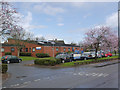
6
St Martin's Road, Bilborough
This is its junction with Strelley Road, once the old road to Strelley Village, but now a main road through modern housing developments. The cast iron signs indicate that this road is older than the general urban development in this area. The building on the left is called Forge Cottage.
Image: © Alan Murray-Rust
Taken: 4 Nov 2007
0.06 miles
7
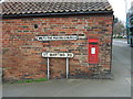
George VI postbox on St Martins Road
Image: © JThomas
Taken: 27 Mar 2017
0.07 miles
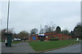
8
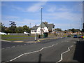
Strelley Road, Strelley estate
Seen at its triangular junction with Moor Road (left), with The Rose pub on the east side of the junction.
Image: © Richard Vince
Taken: 15 Sep 2012
0.07 miles
9
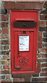
Close up, George VI postbox on St Martins Road
Postbox No. NG8 308.
See Image] for wider view.
Image: © JThomas
Taken: 27 Mar 2017
0.07 miles
10

A view from Moor Road bus stop
Snapped while waiting for the No 77 into town on a bright May morning. The tree, hedge and the corner of Strelley Road and St Martin's Road are in this gridsquare, the houses and Bilborough Church, St Martin of Tours, in Image
Image: © John Sutton
Taken: 16 May 2013
0.07 miles