IMAGES TAKEN NEAR TO
Beckley Road, NOTTINGHAM, NG8 6GX
Introduction
This page details the photographs taken nearby to Beckley Road, NG8 6GX by members of the Geograph project.
The Geograph project started in 2005 with the aim of publishing, organising and preserving representative images for every square kilometre of Great Britain, Ireland and the Isle of Man.

There are currently over 7.5m images from over14,400 individuals and you can help contribute to the project by visiting https://www.geograph.org.uk
Image Map
Images are licensed for reuse under creativecommons.org/licenses/by-sa/2.0
Notes
- Clicking on the map will re-center to the selected point.
- The higher the marker number, the further away the image location is from the centre of the postcode.
Image Listing (9 Images Found)
Images are licensed for reuse under creativecommons.org/licenses/by-sa/2.0
Image
Details
Distance
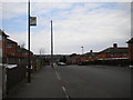
1
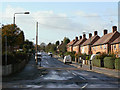
Coleby Road
The main road through Broxtowe Estate. Developed in the late 1930s, the houses with their hipped tiled roofs are typical of Nottingham from the period. The estate has, like many similar ones around the country, suffered from remaining a residual estate while others have prospered more.
Image: © Alan Murray-Rust
Taken: 25 Oct 2009
0.10 miles
2
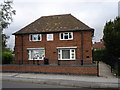
Broxtowe Partnership Trust
Apparently cobbled together from two semis.
Image: © Oxymoron
Taken: 6 Aug 2008
0.17 miles
3
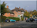
Broxtowe Lane at Coleby Road
An area developed as a large council estate in the late 1930s and after the war. This is a typical small shopping parade, of which there are a number.
Image: © Alan Murray-Rust
Taken: 25 Oct 2009
0.18 miles
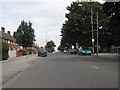
4
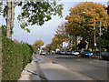
Broxtowe Lane
This is an important through road through the western estates of Nottingham. Clear light after rain, and autumn leaves make an attractive picture in what is not one of Nottingham's more attractive suburbs.
Image: © Alan Murray-Rust
Taken: 25 Oct 2009
0.20 miles
5
East end of Eltham Drive, Bells Lane estate
Image: © Richard Vince
Taken: 28 Mar 2013
0.21 miles
6
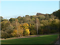
Broxtowe Wood
This forms the basis for Broxtowe Country Park, much of which is on old colliery lands.
Image: © Alan Murray-Rust
Taken: 25 Oct 2009
0.21 miles
7
Broxtowe Lane, Nottingham
Part of a large council estate
Image: © Tom Courtney
Taken: 9 Sep 2005
0.24 miles
8
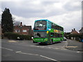
Bus turning onto Broxtowe Lane
One of Nottingham City Transport's large fleet of Scania/East Lancs OmniDekkas waits to make the hard right turn from Sherborne Road onto Broxtowe Lane. It is operating on route 78, which passes through the hearts of Aspley and Broxtowe estates on its way to Strelley estate, encountering a great many speed humps on its way. At this point it leaves Aspley estate, using a short length of Broxtowe Lane to reach Coleby Road, by which it enters Broxtowe estate.
Image: © Richard Vince
Taken: 28 Mar 2013
0.24 miles
9
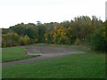
Car Park at Broxtowe Country Park
It's not clear whether this car park was ever used. Certainly the only access today is gated off for vehicles, and as it is largely single track it would have been very inconvenient.
Image: © Alan Murray-Rust
Taken: 25 Oct 2009
0.24 miles