IMAGES TAKEN NEAR TO
Wendover Drive, NOTTINGHAM, NG8 5JW
Introduction
This page details the photographs taken nearby to Wendover Drive, NG8 5JW by members of the Geograph project.
The Geograph project started in 2005 with the aim of publishing, organising and preserving representative images for every square kilometre of Great Britain, Ireland and the Isle of Man.

There are currently over 7.5m images from over14,400 individuals and you can help contribute to the project by visiting https://www.geograph.org.uk
Image Map
Images are licensed for reuse under creativecommons.org/licenses/by-sa/2.0
Notes
- Clicking on the map will re-center to the selected point.
- The higher the marker number, the further away the image location is from the centre of the postcode.
Image Listing (9 Images Found)
Images are licensed for reuse under creativecommons.org/licenses/by-sa/2.0
Image
Details
Distance
1
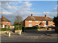
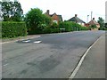
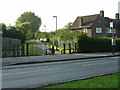
Welstead Avenue from Browtowe Lane
This is the entrance to the Aspley Estate from Broxtowe Lane. The Bulwell Stone garden walls are a relatively unusual feature for interwar council housing.
Image: © SK53
Taken: 1 May 2013
0.12 miles
2
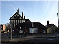
The Barleycorn, Cinderhill
Yet another pub boarded up, perhaps awaiting a new tenant or even the demolition crew - a sign of our changing society?
Image: © Oxymoron
Taken: 18 Nov 2008
0.16 miles
3
The Barleycorn
Another former landmark bites the dust.
Image: © David Lally
Taken: 26 Jul 2008
0.18 miles
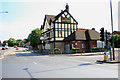
4
The Barleycorn has gone
Former landmark pub on the A610 out of Nottingham has now been demolished, it's been closed for at least 18 months Image Image
Image: © David Lally
Taken: 8 Feb 2010
0.18 miles
6
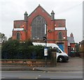
AgeUK - Sybil Levin Centre
The Sybil Levin Centre is a multi purpose facility providing a range of services and activities for older people aged over 55 in the Nottingham and Cinderhill areas
Image: © Anthony Parkes
Taken: 31 Oct 2013
0.22 miles
7
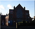
The Sybil Levin Centre, Nuthall Road
This was obviously once a church (no doubt nonconformist, as the C of E church http://www.geograph.org.uk/photo/1050029 is only a few metres further along the road), as is marked as such on my older version of the OS 1:50000 map; now it is the Nottinghamshire HQ of Age Concern.
Image: © Oxymoron
Taken: 18 Nov 2008
0.23 miles
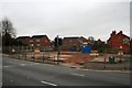
8
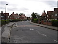
Minver Crescent, Aspley
Typical of the housing in this area of Aspley.
Image: © Oxymoron
Taken: 6 Aug 2008
0.23 miles
9
Former colliery railway
This footpath has been created on the alignment of an old colliery railway that ran parallel to Nuthall Road, continuing to serve a landsale wharf into the 1960s.
Image: © Alan Murray-Rust
Taken: 4 Jun 2008
0.24 miles