IMAGES TAKEN NEAR TO
Wendover Drive, NOTTINGHAM, NG8 5JP
Introduction
This page details the photographs taken nearby to Wendover Drive, NG8 5JP by members of the Geograph project.
The Geograph project started in 2005 with the aim of publishing, organising and preserving representative images for every square kilometre of Great Britain, Ireland and the Isle of Man.

There are currently over 7.5m images from over14,400 individuals and you can help contribute to the project by visiting https://www.geograph.org.uk
Image Map
Images are licensed for reuse under creativecommons.org/licenses/by-sa/2.0
Notes
- Clicking on the map will re-center to the selected point.
- The higher the marker number, the further away the image location is from the centre of the postcode.
Image Listing (5 Images Found)
Images are licensed for reuse under creativecommons.org/licenses/by-sa/2.0
Image
Details
Distance
1
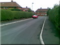
Minver Crescent, Aspley
Typical of the housing in this area of Aspley.
Image: © Oxymoron
Taken: 6 Aug 2008
0.13 miles
2
Hilcot Drive
One of the "spokes" of the Aspley Estate. This one leads directly east from the central hub.
Image: © David Lally
Taken: 15 Dec 2009
0.17 miles
4
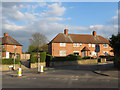
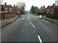
Welstead Avenue from Browtowe Lane
This is the entrance to the Aspley Estate from Broxtowe Lane. The Bulwell Stone garden walls are a relatively unusual feature for interwar council housing.
Image: © SK53
Taken: 1 May 2013
0.21 miles