IMAGES TAKEN NEAR TO
Abingdon Square, NOTTINGHAM, NG8 5HX
Introduction
This page details the photographs taken nearby to Abingdon Square, NG8 5HX by members of the Geograph project.
The Geograph project started in 2005 with the aim of publishing, organising and preserving representative images for every square kilometre of Great Britain, Ireland and the Isle of Man.

There are currently over 7.5m images from over14,400 individuals and you can help contribute to the project by visiting https://www.geograph.org.uk
Image Map
Images are licensed for reuse under creativecommons.org/licenses/by-sa/2.0
Notes
- Clicking on the map will re-center to the selected point.
- The higher the marker number, the further away the image location is from the centre of the postcode.
Image Listing (20 Images Found)
Images are licensed for reuse under creativecommons.org/licenses/by-sa/2.0
Image
Details
Distance
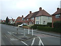
1
Hilcot Drive
One of the "spokes" of the Aspley Estate. This one leads directly east from the central hub.
Image: © David Lally
Taken: 15 Dec 2009
0.11 miles
2
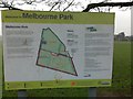
Welcome sign
In Melbourne Park, Aspley, Nottingham.
Behind to the right the tower of Image can be seen.
Image: © David Lally
Taken: 15 Dec 2009
0.13 miles
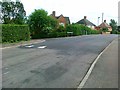
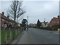
7
Road Improvements
on Melborne Road, Aspley, Nottingham
Image: © Tom Courtney
Taken: 9 Sep 2005
0.21 miles
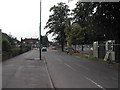
9
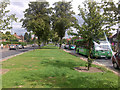
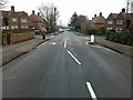
Melbourne Road, Aspley
Wide boulevard typical of the council estates on the north west of Nottingham.
Image: © David Lally
Taken: 18 Aug 2009
0.22 miles
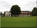
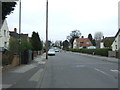
10
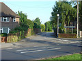
The entrance to Melbourne Park Medical centre
The reason that there is a gap between the houses is that this is the alignment of a former colliery railway that ran parallel to Nuthall Road. It continued to serve a landsale wharf into the 1960s. It crossed Melbourne Road by a level crossing.
Image: © Alan Murray-Rust
Taken: 4 Jun 2008
0.23 miles