IMAGES TAKEN NEAR TO
Bryan Court, NOTTINGHAM, NG8 5HE
Introduction
This page details the photographs taken nearby to Bryan Court, NG8 5HE by members of the Geograph project.
The Geograph project started in 2005 with the aim of publishing, organising and preserving representative images for every square kilometre of Great Britain, Ireland and the Isle of Man.

There are currently over 7.5m images from over14,400 individuals and you can help contribute to the project by visiting https://www.geograph.org.uk
Image Map
Images are licensed for reuse under creativecommons.org/licenses/by-sa/2.0
Notes
- Clicking on the map will re-center to the selected point.
- The higher the marker number, the further away the image location is from the centre of the postcode.
Image Listing (46 Images Found)
Images are licensed for reuse under creativecommons.org/licenses/by-sa/2.0
Image
Details
Distance
1
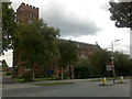
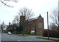
St Margaret's, Aspley Lane
On approaching this "modernist gothic" church I assumed that it must be a Catholic Church, built in the first half of the 20th century. It is however, C of E. My estimate of the building date still stands.
Update Nov 2012. More information is now available on Tim Heaton's picture, which also shows the addition of solar panels Image
Image: © David Lally
Taken: 18 Aug 2009
0.07 miles
2
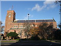
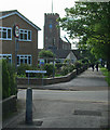
Church of St Margaret, Aspley
A Charismatic Evangelical Anglican church. It was consecrated in 1936, having been built to serve new communities settling in the outskirts of Nottingham in the 1920s and 30s. Funding was provided by John Dane Player of the famous cigarette manufacturers. Note the new style of roof covering.
Image: © Tim Heaton
Taken: 11 Nov 2012
0.08 miles
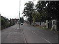
3
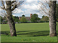
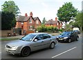
Melbourne Park
Melbourne Park, with its children's playground, pavilion and many football and cricket pitches, was developed along with the western suburbs in the 1930s. This view across the park, from the Newlyn Gardens entrance, shows redbrick St Margaret's Church on Aspley Lane, which also dates from the thirties. The slight rise in the ground from which the photograph was taken is all that remains of the embankment of the National Coal Board railway system which connected Cinderhill Colliery and the landsale wharf on Nuthall Road. There was a huge fan of sidings to the right of here (where the Staindale Drive housing development now is), which lasted into the 1960s.
Image: © John Sutton
Taken: 11 May 2010
0.08 miles
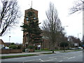
6
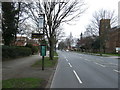
Aspley Lane and St Margaret's Church
A view against the light on a May morning. The red-brick church was built in 1936 as part of the City Council's Aspley Estate. The westward expansion of the city began in 1932.
Image: © John Sutton
Taken: 13 May 2014
0.09 miles
7
Aspley Hall Cottages and a stream of traffic
These four cottages, photographed over late-rush-hour traffic waiting to cross Western Boulevard, date from 1902. They are all that remains of the Aspley Hall estate - the hall was demolished in 1968. "The history of Aspley up to 1928 is the history of one large house, Aspley Hall. From then onwards Aspley is a Nottingham suburb which is largely a creation by the City Council" (Geoffrey Oldfield: "The Illustrated History of Nottingham's Suburbs").
Image: © John Sutton
Taken: 13 May 2014
0.11 miles
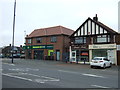
10
Road Improvements
on Melborne Road, Aspley, Nottingham
Image: © Tom Courtney
Taken: 9 Sep 2005
0.13 miles