IMAGES TAKEN NEAR TO
Annan Court, NOTTINGHAM, NG8 5HA
Introduction
This page details the photographs taken nearby to Annan Court, NG8 5HA by members of the Geograph project.
The Geograph project started in 2005 with the aim of publishing, organising and preserving representative images for every square kilometre of Great Britain, Ireland and the Isle of Man.

There are currently over 7.5m images from over14,400 individuals and you can help contribute to the project by visiting https://www.geograph.org.uk
Image Map
Images are licensed for reuse under creativecommons.org/licenses/by-sa/2.0
Notes
- Clicking on the map will re-center to the selected point.
- The higher the marker number, the further away the image location is from the centre of the postcode.
Image Listing (51 Images Found)
Images are licensed for reuse under creativecommons.org/licenses/by-sa/2.0
Image
Details
Distance
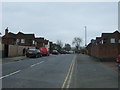
1
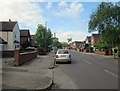
Aspley: Robins Wood Road
Part of the rapid westward expansion of the city either side of the Second World War. This consisted mostly of council housing, with some roads of private houses.
Image: © John Sutton
Taken: 13 May 2014
0.07 miles
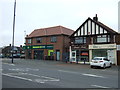
2
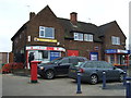
Aspley Post Office
On Aspley Lane.
Showing position of Postbox No. NG8 253.
See Image] for postbox.
Image: © JThomas
Taken: 27 Mar 2017
0.07 miles
3
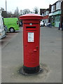
George V postbox outside Aspley Post Office
Postbox No. NG8 253.
See Image] for context.
Image: © JThomas
Taken: 27 Mar 2017
0.08 miles
4
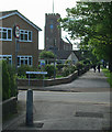
Aspley Lane and St Margaret's Church
A view against the light on a May morning. The red-brick church was built in 1936 as part of the City Council's Aspley Estate. The westward expansion of the city began in 1932.
Image: © John Sutton
Taken: 13 May 2014
0.08 miles
5
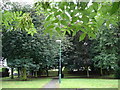
Hidden Green Space
This small green space is hidden away at the junction of 3 or 4 culs-de-sac.
Image: © Oxymoron
Taken: 6 Aug 2008
0.08 miles
6

Aspley Hall Cottages and a stream of traffic
These four cottages, photographed over late-rush-hour traffic waiting to cross Western Boulevard, date from 1902. They are all that remains of the Aspley Hall estate - the hall was demolished in 1968. "The history of Aspley up to 1928 is the history of one large house, Aspley Hall. From then onwards Aspley is a Nottingham suburb which is largely a creation by the City Council" (Geoffrey Oldfield: "The Illustrated History of Nottingham's Suburbs").
Image: © John Sutton
Taken: 13 May 2014
0.08 miles
7
Robin's Wood Road, Aspley
Looking south west from Aspley Lane.
Image: © JThomas
Taken: 27 Mar 2017
0.08 miles
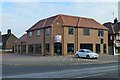
10
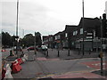
Post Office and Shops
located on Aspley Lane, Nottingham. The road that is closed off in Robin's Wood Road
Image: © Tom Courtney
Taken: 9 Sep 2005
0.09 miles