IMAGES TAKEN NEAR TO
Bracknell Crescent, NOTTINGHAM, NG8 5FF
Introduction
This page details the photographs taken nearby to Bracknell Crescent, NG8 5FF by members of the Geograph project.
The Geograph project started in 2005 with the aim of publishing, organising and preserving representative images for every square kilometre of Great Britain, Ireland and the Isle of Man.

There are currently over 7.5m images from over14,400 individuals and you can help contribute to the project by visiting https://www.geograph.org.uk
Image Map
Images are licensed for reuse under creativecommons.org/licenses/by-sa/2.0
Notes
- Clicking on the map will re-center to the selected point.
- The higher the marker number, the further away the image location is from the centre of the postcode.
Image Listing (28 Images Found)
Images are licensed for reuse under creativecommons.org/licenses/by-sa/2.0
Image
Details
Distance
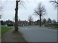
1
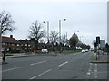
Western Boulevard (A6514)
Looking north east at the junction with Wilkinson Street.
Image: © JThomas
Taken: 27 Mar 2017
0.14 miles

4
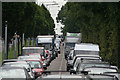
Ring Road Rush
Stationary traffic on Western Boulevard approaching Basford Church
Image: © Alan Murray-Rust
Taken: 24 Jun 2008
0.15 miles
6
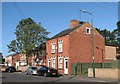
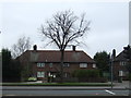
Basford Road: new and old
Lineker's Cottages date from 1879, the houses to the left from more recent years.
Image: © John Sutton
Taken: 13 Sep 2011
0.16 miles
7
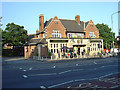
Newcastle Arms
The name is derived from the Duke of Newcastle who owned most of the coal concessions in the area. The pub is a typical 1930s roadhouse, designed to serve the council estate behind it. Note the fine ceramic frontage complete with coloured coat of arms. This pub has not suffered from unnecessary renaming!
Image: © Alan Murray-Rust
Taken: 4 Jun 2008
0.17 miles
8
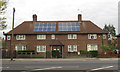
Inter-war terrace with solar panels, Nuthall Road
This 4 house terrace with small porches for the central houses was probably the commonest type of the council housing built by Nottingham Borough Council between the wars. A few were also completed after WWII on the Bestwood Estate. This one on the North side of Nuthall Road is part of the Whitemoor Estate, and nicely shows the solar panels now found on around 4,500 houses owned by Nottingham City Homes, the successor organisation to the borough's housing department.
Image: © SK53
Taken: 1 May 2013
0.17 miles
9
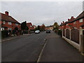
Wilkinson Street
Looking north west towards the junction with Western Boulevard (A6514).
Image: © JThomas
Taken: 27 Mar 2017
0.17 miles