IMAGES TAKEN NEAR TO
Tintern Drive, NOTTINGHAM, NG8 5FD
Introduction
This page details the photographs taken nearby to Tintern Drive, NG8 5FD by members of the Geograph project.
The Geograph project started in 2005 with the aim of publishing, organising and preserving representative images for every square kilometre of Great Britain, Ireland and the Isle of Man.

There are currently over 7.5m images from over14,400 individuals and you can help contribute to the project by visiting https://www.geograph.org.uk
Image Map
Images are licensed for reuse under creativecommons.org/licenses/by-sa/2.0
Notes
- Clicking on the map will re-center to the selected point.
- The higher the marker number, the further away the image location is from the centre of the postcode.
Image Listing (123 Images Found)
Images are licensed for reuse under creativecommons.org/licenses/by-sa/2.0
Image
Details
Distance

6

Ring Road Rush
Stationary traffic on Western Boulevard approaching Basford Church
Image: © Alan Murray-Rust
Taken: 24 Jun 2008
0.07 miles
8
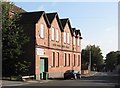
Basford Road: former Sunday School
The original name of this building, Baptist Centenary Sunday Schools, shows clearly in the low sunlight of a September morning. The building is now occupied by Sherwood Fabrics. It dates from 1899. For another view, see Image
Image: © John Sutton
Taken: 13 Sep 2011
0.10 miles