IMAGES TAKEN NEAR TO
Cyril Avenue, NOTTINGHAM, NG8 5BA
Introduction
This page details the photographs taken nearby to Cyril Avenue, NG8 5BA by members of the Geograph project.
The Geograph project started in 2005 with the aim of publishing, organising and preserving representative images for every square kilometre of Great Britain, Ireland and the Isle of Man.

There are currently over 7.5m images from over14,400 individuals and you can help contribute to the project by visiting https://www.geograph.org.uk
Image Map
Images are licensed for reuse under creativecommons.org/licenses/by-sa/2.0
Notes
- Clicking on the map will re-center to the selected point.
- The higher the marker number, the further away the image location is from the centre of the postcode.
Image Listing (135 Images Found)
Images are licensed for reuse under creativecommons.org/licenses/by-sa/2.0
Image
Details
Distance
1

Bobbers Mill: Cyril Avenue
The newish houses on the east side of Cyril Avenue, backing on to the railway, are only just in SK5541.
Image: © John Sutton
Taken: 20 Nov 2009
0.03 miles
2
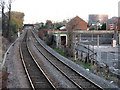
View from the footbridge at Bobbers Mill
In the distance are the next footbridge, at Wistow Close, and behind it Wilkinson Street road bridge, with a Basford gasholder further away on the right.
Image: © John Sutton
Taken: 20 Nov 2009
0.04 miles
3
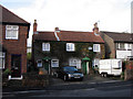
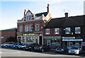
Bobbers Mill: cottages on Cyril Avenue
This is one of the few buildings in Bobbers Mill dating from before the late 19th century, when the area changed from a village to an industrial suburb.
Image: © John Sutton
Taken: 20 Nov 2009
0.05 miles
4
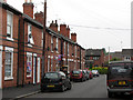
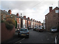
Albert Avenue on royal wedding day
Quite early on the bank-holiday morning there was only limited evidence of any wedding-fever to come. The newer houses on Cyril Avenue are in the background.
Image: © John Sutton
Taken: 29 Apr 2011
0.05 miles

7
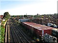
The Leen Valley at Bobbers Mill
The canalised and partly-culverted Leen runs behind DTN Pallets' yard, which occupies the site of the mill which gave the area its name. The Midland Railway line to Mansfield and Worksop was the first of three built to serve the Leen Valley's pits and the only one which remains. The chimney in the centre is all that remains of Gerard's Soap Works (demolished in April 2011); the former Shipstone's Brewery (Image]) is on the skyline to the right of centre. The view is from the footbridge: Image] is the view in the other direction.
Image: © John Sutton
Taken: 13 Sep 2012
0.06 miles

10
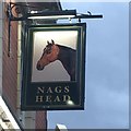
Bobbers Mill: The Nag's Head
Originally a Home Brewery tied house, with the initials HB above the dormer window.
Image: © John Sutton
Taken: 13 Sep 2012
0.08 miles