IMAGES TAKEN NEAR TO
Westwick Road, NOTTINGHAM, NG8 4HD
Introduction
This page details the photographs taken nearby to Westwick Road, NG8 4HD by members of the Geograph project.
The Geograph project started in 2005 with the aim of publishing, organising and preserving representative images for every square kilometre of Great Britain, Ireland and the Isle of Man.

There are currently over 7.5m images from over14,400 individuals and you can help contribute to the project by visiting https://www.geograph.org.uk
Image Map
Images are licensed for reuse under creativecommons.org/licenses/by-sa/2.0
Notes
- Clicking on the map will re-center to the selected point.
- The higher the marker number, the further away the image location is from the centre of the postcode.
Image Listing (11 Images Found)
Images are licensed for reuse under creativecommons.org/licenses/by-sa/2.0
Image
Details
Distance
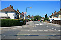
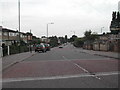
2
Bramhall Road, Bilborough
View along Bramhall Road from its junction with Bilborough Road, showing the tower blocks of the city of Nottingham in the far distance.
Image: © Oxymoron
Taken: 10 Jul 2008
0.10 miles
3
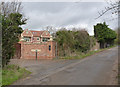
Ashlands, Bilborough Road
A large modern house on the edge of Nottingham. The lane is a bridleway up to Strelley Village.
Image: © Alan Murray-Rust
Taken: 18 Mar 2014
0.12 miles
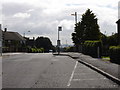
4
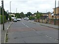
Bilborough Road
Much has changed since this 1976 view. What is now the A6002, providing a fairly fast road around the western edge of Nottingham, was then the B6004 and not much more than a country lane. This is the junction with Bramhall Road, where the vast Bilborough Estate gives way to Trowell Moor - green belt land that has not been built on to this day. Note the blue bus stop flag; this was a rare survivor from the days before Midland General was taken over by Trent and the standard National Bus Company style flag was adopted. It marked the terminus of a service from Nottingham that, by 1976, only operated at peak times - it was listed in timetables as 'Strelley Lane', which presumably refers to the bridleway that can be seen leading off just before the first house. Trent ceased to run here a few years after the photograph was taken.
Image: © Stephen McKay
Taken: Unknown
0.13 miles
5
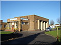
Bilborough Education Action Zone Centre, Westwick Road
Image: © Oxymoron
Taken: 3 Dec 2008
0.15 miles
6
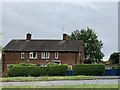
Houses on Bilborough Road
At the junction with Cockington Road.
Image: © Andrew Abbott
Taken: 19 Jun 2020
0.18 miles
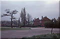
7
Bilborough Road
I think this short stretch of road must be part of the original Bilborough Road, now bypassed by the modern road (just visible on the left of the photo). There are about 10 or so houses on this (western) side of the road; presumably this section of the old road has been retained here to give these houses some protection from the new road.
Image: © Oxymoron
Taken: 10 Aug 2008
0.19 miles
8
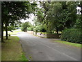
Council Estate, Cockington Road, Bilborough
Recreating this 'First' for the square http://www.geograph.org.uk/photo/51192 .
Very little has changed.
Image: © Alan Murray-Rust
Taken: 18 Aug 2021
0.19 miles
9
Council Estate, Cockington Road, Bilborough
One of the estates in Nottingham
Image: © Tom Courtney
Taken: 9 Sep 2005
0.23 miles
10
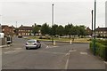
Birchover Road approaching Burnside Green
Image: © Mark Anderson
Taken: 22 Jul 2018
0.24 miles