IMAGES TAKEN NEAR TO
Baythorn Road, NOTTINGHAM, NG8 4FB
Introduction
This page details the photographs taken nearby to Baythorn Road, NG8 4FB by members of the Geograph project.
The Geograph project started in 2005 with the aim of publishing, organising and preserving representative images for every square kilometre of Great Britain, Ireland and the Isle of Man.

There are currently over 7.5m images from over14,400 individuals and you can help contribute to the project by visiting https://www.geograph.org.uk
Image Map
Images are licensed for reuse under creativecommons.org/licenses/by-sa/2.0
Notes
- Clicking on the map will re-center to the selected point.
- The higher the marker number, the further away the image location is from the centre of the postcode.
Image Listing (15 Images Found)
Images are licensed for reuse under creativecommons.org/licenses/by-sa/2.0
Image
Details
Distance
1
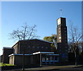
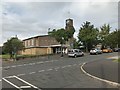
Parish Church of St John the Baptist, Bilborough
According to a passerby, this is exactly 50 years old.
Image: © Oxymoron
Taken: 3 Dec 2008
0.09 miles
2
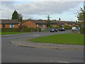
Bramerton Road
These modern bungalows, intended for elderly residents, replaced a large development of traditional post war pre-fabs.
Image: © Alan Murray-Rust
Taken: 25 Oct 2009
0.09 miles
5
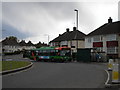
Bus on Burnside Green, Bilborough estate
A 35 to Bulwell pauses at a bus stop on Burnside Green, a roundabout near to the centre of Bilborough estate.
Image: © Richard Vince
Taken: 12 May 2010
0.12 miles
6
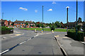
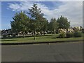
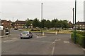
Council Estate Roundabout
Forming the junction of Burnside Road (to the right), Bracebridge Drive (straight forward), Hanslope Crescent (to the left) and Birchover Road - from where the picture was taken.
Image: © David Lally
Taken: 9 Jun 2008
0.12 miles
9
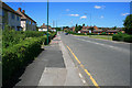
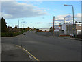
Birchover Road approaching Burnside Green
Image: © Mark Anderson
Taken: 22 Jul 2018
0.12 miles
10
Glaisdale Drive
The southern part of the large Bilborough estate was zoned for industry, and Glaisdale Drive provides the boundary between residential and industry.
Image: © Alan Murray-Rust
Taken: 25 Oct 2009
0.14 miles