IMAGES TAKEN NEAR TO
Bilborough Road, NOTTINGHAM, NG8 4DW
Introduction
This page details the photographs taken nearby to Bilborough Road, NG8 4DW by members of the Geograph project.
The Geograph project started in 2005 with the aim of publishing, organising and preserving representative images for every square kilometre of Great Britain, Ireland and the Isle of Man.

There are currently over 7.5m images from over14,400 individuals and you can help contribute to the project by visiting https://www.geograph.org.uk
Image Map
Images are licensed for reuse under creativecommons.org/licenses/by-sa/2.0
Notes
- Clicking on the map will re-center to the selected point.
- The higher the marker number, the further away the image location is from the centre of the postcode.
Image Listing (20 Images Found)
Images are licensed for reuse under creativecommons.org/licenses/by-sa/2.0
Image
Details
Distance
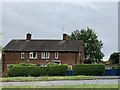
1
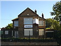
Stotfield Road, Bilborough
A residential road at the western end of Bilborough estate. Most of the prefab houses on the estate have been refurbished, with brick outer walls the most noticeable improvement; however, there are exceptions, as can be seen here.
Image: © Richard Vince
Taken: 24 Aug 2013
0.05 miles
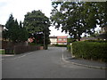
2
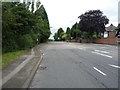
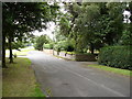
Bilborough Road
The lane on the right is the old road prior to its improvement as part of the outer loop road for Nottingham. Note also the boundary marker http://www.geograph.org.uk/photo/3902752 to the left.
Image: © Alan Murray-Rust
Taken: 18 Mar 2014
0.07 miles
3
Boundary marker, Bilborough Road
This has been moved, probably unofficially, from its original location on the opposite side of the lane just visible in the foreground. It is one of the standard cast iron markers erected by the City as part of the boundary revision of 1933.
Image: © Alan Murray-Rust
Taken: 18 Mar 2014
0.08 miles
4
Linsdale Close, Bilborough
A very short residential cul de sac on the western edge of Bilborough estate; the photographer is standing at one end, and the houses in the centre are opposite the other, on Stotfield Road.
Image: © Richard Vince
Taken: 24 Aug 2013
0.08 miles
5
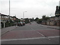
Council Estate, Cockington Road, Bilborough
One of the estates in Nottingham
Image: © Tom Courtney
Taken: 9 Sep 2005
0.11 miles
6
Council Estate, Cockington Road, Bilborough
Recreating this 'First' for the square http://www.geograph.org.uk/photo/51192 .
Very little has changed.
Image: © Alan Murray-Rust
Taken: 18 Aug 2021
0.12 miles
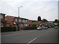
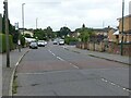
7
Houses on Bilborough Road
At the junction with Cockington Road.
Image: © Andrew Abbott
Taken: 19 Jun 2020
0.14 miles
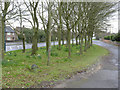
9
Bilborough Road
I think this short stretch of road must be part of the original Bilborough Road, now bypassed by the modern road (just visible on the left of the photo). There are about 10 or so houses on this (western) side of the road; presumably this section of the old road has been retained here to give these houses some protection from the new road.
Image: © Oxymoron
Taken: 10 Aug 2008
0.17 miles