IMAGES TAKEN NEAR TO
Holbeck Road, NOTTINGHAM, NG8 3PB
Introduction
This page details the photographs taken nearby to Holbeck Road, NG8 3PB by members of the Geograph project.
The Geograph project started in 2005 with the aim of publishing, organising and preserving representative images for every square kilometre of Great Britain, Ireland and the Isle of Man.

There are currently over 7.5m images from over14,400 individuals and you can help contribute to the project by visiting https://www.geograph.org.uk
Image Map
Images are licensed for reuse under creativecommons.org/licenses/by-sa/2.0
Notes
- Clicking on the map will re-center to the selected point.
- The higher the marker number, the further away the image location is from the centre of the postcode.
Image Listing (27 Images Found)
Images are licensed for reuse under creativecommons.org/licenses/by-sa/2.0
Image
Details
Distance
1
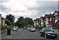
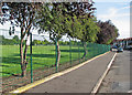
Holbeck Road
Typical detached houses built when the city expanded westwards from the 1930s onwards. The trees mark the edge of some of the many allotments which border Western Boulevard.
Image: © John Sutton
Taken: 12 Jul 2011
0.03 miles
2
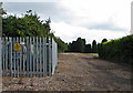
Holbeck Road: a railway long ago
An uninteresting picture of part of an electricity sub-station and some gravel - but to those interested in Nottingham's railway history there is more to it. From the 19th century until the building of Western Boulevard and the houses either side of it in the 1930s, a railway linking Babbington (Cinderhill) Colliery and the Nottingham Canal at a wharf immediately south of Wollaton Road ran north and south here. Its course is marked by the eastern edge of the allotments to the left and the western boundary of the Girls' High School (formerly John Player & Sons) sports ground (beyond the garden hedge on the right).
For other vestiges of the Babbington Colliery line, see Image], Image], Image], Image] and Image
Image: © John Sutton
Taken: 12 Jul 2011
0.05 miles
3
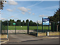
Grassington Road: playing-field entrance
Now owned by Nottingham Girls' High School, this huge playing field was once Players Rec, home of Players Athletic cricket, football and other sports teams. All the big Nottingham firms had fine sports grounds, and John Player & Sons was no exception. (The Raleigh ground was at Wollaton and Boots at Lady Bay.)
Image: © John Sutton
Taken: 27 Aug 2010
0.05 miles
4
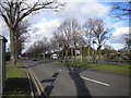
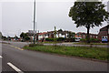
Western Boulevard, Aspley
Looking north along Western Boulevard (part of Nottingham's ring road) as it approaches Aspley Lane.
Image: © Richard Vince
Taken: 1 Feb 2013
0.08 miles
5
Girls' High School playing field, Grassington Road
Now owned by Nottingham Girls' High School, this huge playing field was once Players Rec, home of Players Athletic cricket, football and other sports teams. In the days of benevolent employers, all the big Nottingham firms had fine sports grounds, and John Player & Sons was no exception. (The Raleigh ground was at Wollaton and Boots at Lady Bay.)
Image: © John Sutton
Taken: 27 Aug 2010
0.09 miles
6
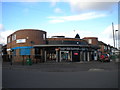
Bismillah Boutique, Ainsley Estate
Located on the corner of Northdown Road (left) and Grassington Road in Ainsley Estate, this distinctive building was presumably some sort of grocery shop before it became a boutique. According to Wikipedia, "Bismillah" is an Arabic phrase meaning "in the name of God", and is perhaps best known in the English speaking world for its presence in the song "Bohemian Rhapsody" by Queen.
Image: © Richard Vince
Taken: 1 Feb 2013
0.13 miles
7

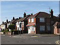
Northdown Road
Private houses were built at this end of the Ainsley Estate. The first of the council houses on Northdown Road are in the distance, where the road curves to the right. The Woodlands flats dominate the Radford skyline in the way the now demolished John Player & Sons cigarette factory once did. To their left is the spire of All Saints' Church, still further away.
Image: © John Sutton
Taken: 12 Jul 2011
0.15 miles
8
Grassington Road: former beer-off
This detached house on the corner of Grassington and Northdown Roads was, as the faded painted signs for Whitbread and Guinness show, once a corner off-licence (or beer-off, as Nottinghamians called them). In the High and Far-off Times, under-age drinkers could buy pint bottles of Shipstone's Nutbrown Ale to drink whilst idling away the evening on the street corner opposite.
Image: © John Sutton
Taken: 27 Aug 2010
0.16 miles
9
Western Boulevard at Franklyn Gardens, Nottingham
Image: © Ian S
Taken: 29 Aug 2020
0.16 miles
10
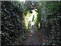
Footpath through the allotments
This undistinguished photo could be anywhere, I know. It is half-way along the footpath through the allotments between Ascot Road and New Bridge. These allotments feature in Radford author Alan Sillitoe's short story "The Decline and Fall of Frankie Buller". This path hasn't changed in the fifty years since I cycled along it as a lad, and was probably the same when fictional hooligan Frankie Buller created mayhem here in the 1930s.
Image: © John Sutton
Taken: 20 Nov 2009
0.18 miles