IMAGES TAKEN NEAR TO
West Holme Gardens, NOTTINGHAM, NG8 3NY
Introduction
This page details the photographs taken nearby to West Holme Gardens, NG8 3NY by members of the Geograph project.
The Geograph project started in 2005 with the aim of publishing, organising and preserving representative images for every square kilometre of Great Britain, Ireland and the Isle of Man.

There are currently over 7.5m images from over14,400 individuals and you can help contribute to the project by visiting https://www.geograph.org.uk
Image Map
Images are licensed for reuse under creativecommons.org/licenses/by-sa/2.0
Notes
- Clicking on the map will re-center to the selected point.
- The higher the marker number, the further away the image location is from the centre of the postcode.
Image Listing (34 Images Found)
Images are licensed for reuse under creativecommons.org/licenses/by-sa/2.0
Image
Details
Distance
1
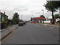
Western Boulevard at Franklyn Gardens, Nottingham
Image: © Ian S
Taken: 29 Aug 2020
0.06 miles
2

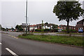
Western Boulevard, Beechdale
Private housing on Nottingham's ring road.
Image: © Stephen McKay
Taken: 3 Jul 2008
0.12 miles
3
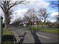
Western Boulevard, Aspley
Looking north along Western Boulevard (part of Nottingham's ring road) as it approaches Aspley Lane.
Image: © Richard Vince
Taken: 1 Feb 2013
0.12 miles
4
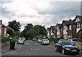
Holbeck Road
Typical detached houses built when the city expanded westwards from the 1930s onwards. The trees mark the edge of some of the many allotments which border Western Boulevard.
Image: © John Sutton
Taken: 12 Jul 2011
0.13 miles
5
Trentham Gardens, Aspley
Apparently named after the country estate on the fringe of the Potteries, this road is part of a suburban development south of the middle section of Aspley Lane.
Image: © Richard Vince
Taken: 1 Feb 2013
0.14 miles
6
Government Buildings
located on Chalfont Drive in Nottingham
Image: © Tom Courtney
Taken: 9 Sep 2005
0.15 miles
7
Beechdale Swimming Centre
From the mouth of the pedestrian underpass beneath Western Boulevard
Image: © David Lally
Taken: 28 Nov 2007
0.15 miles

9
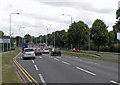
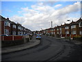
Western Boulevard: Beechdale Road junction
This view north from the railway bridge shows traffic stopping at the Beechdale Road lights. Western Boulevard, part of the ring road, was built in the 1930s at the beginning of the huge westward expansion of the city before and after the war. Until then, Beechdale Road was a footpath from Radford to Bilborough. The Baths are out-of-picture to the left, Robert Shaw Primary School and the Ainsley Estate to the right. Fifty-odd years ago I was nearly knocked off my bike here when turning right to go down the twitchel on to the estate.
Image: © John Sutton
Taken: 12 Jul 2011
0.15 miles
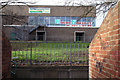
10
Holbeck Road: a railway long ago
An uninteresting picture of part of an electricity sub-station and some gravel - but to those interested in Nottingham's railway history there is more to it. From the 19th century until the building of Western Boulevard and the houses either side of it in the 1930s, a railway linking Babbington (Cinderhill) Colliery and the Nottingham Canal at a wharf immediately south of Wollaton Road ran north and south here. Its course is marked by the eastern edge of the allotments to the left and the western boundary of the Girls' High School (formerly John Player & Sons) sports ground (beyond the garden hedge on the right).
For other vestiges of the Babbington Colliery line, see Image], Image], Image], Image] and Image
Image: © John Sutton
Taken: 12 Jul 2011
0.15 miles