IMAGES TAKEN NEAR TO
Saltburn Road, NOTTINGHAM, NG8 3FY
Introduction
This page details the photographs taken nearby to Saltburn Road, NG8 3FY by members of the Geograph project.
The Geograph project started in 2005 with the aim of publishing, organising and preserving representative images for every square kilometre of Great Britain, Ireland and the Isle of Man.

There are currently over 7.5m images from over14,400 individuals and you can help contribute to the project by visiting https://www.geograph.org.uk
Image Map
Images are licensed for reuse under creativecommons.org/licenses/by-sa/2.0
Notes
- Clicking on the map will re-center to the selected point.
- The higher the marker number, the further away the image location is from the centre of the postcode.
Image Listing (13 Images Found)
Images are licensed for reuse under creativecommons.org/licenses/by-sa/2.0
Image
Details
Distance
1

Bilborough: Wigman Road
This view from the roundabout at the end of Hollington Road shows the start of Wigman Road, part of the huge expansion of the western suburbs after the war. The bungalows on the right were built on the foundations of the original Prefabs; further up were prefabricated BISF (British Iron & Steel Federation) semis, with their distinctive first-floor corrugated walling.
Image: © John Sutton
Taken: 22 Jun 2011
0.09 miles
2

Woodyard Lane - the Beechdale end
This bridleway runs from the Beechdale Estate to Lambourne Drive, Wollaton.
Image: © John Sutton
Taken: 22 Jun 2011
0.13 miles
3

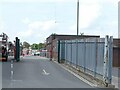
?Please do not lean or sit?
The condition of the wall is self explanatory; it was probably attacked by a heavy vehicle making its way to the Council depot at the top of the road.
Image: © Alan Murray-Rust
Taken: 3 Aug 2021
0.13 miles
4
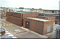
Primary Substation, Bilborough
A primary substation that supplies power to a large area of Nottingham.
Image: © Garth Newton
Taken: 9 Aug 2000
0.16 miles
5
Primary Substation, Bilborough
Taken on an attempt to recreate this 'First' for the square https://www.geograph.org.uk/photo/18959 . Not replicable without access to the upper floor of the Nottingham City Council depot at Woolsthorpe Close!
Image: © Alan Murray-Rust
Taken: 3 Aug 2021
0.17 miles
6
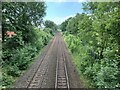
Radford to Trowell Railway
Opened in 1875 by the Midland Railway.
Image: © Andrew Abbott
Taken: 3 Jul 2021
0.18 miles
7
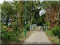
Woodyard Lane
The southern approach to the railway bridge. There has been some recent tree clearance compared with John Sutton's 2011 view https://www.geograph.org.uk/photo/2473437 , taken from a few metres further back.
Image: © Alan Murray-Rust
Taken: 3 Aug 2021
0.19 miles
8

Radford to Trowell Railway
In Bilborough. Opened in 1875 by the Midland Railway.
Image: © Andrew Abbott
Taken: 3 Jul 2021
0.20 miles
9
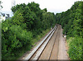
West from Woodyard Lane railway bridge
The line from Radford Junction to Trowell, on the Erewash Valley Line, was built as a short cut for trains to and from the north, avoiding the bottleneck at Toton; it also served Wollaton Colliery, beyond the trees, whose site has long been cleared. Fifty or more years ago this was an exciting place for trainspotters as expresses passed at some speed and were usually pulled by Jubilee Class engines with big brass nameplates, such as Nottingham's "Travancore" or "Hong Kong".
Image: © John Sutton
Taken: 22 Jun 2011
0.20 miles
10
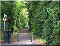
Woodyard Lane - the Wollaton End
This bridleway links Wollaton and the Beechdale Estate. Fifty years or more ago, this was a good place for eleven-year-olds: you could collect engine numbers from the bridge over the Radford-Trowell line at the top of the slope ahead, or fish for newts in the canal, which the lane had once crossed just behind the camera. The Nottingham Canal north of Lenton was abandoned in 1937, but its course and the decaying locks were not cleared away in these parts until the 1980s. Torvill Close - named for Nottingham's Olympic ice-skating champion - parallels its course. Alan Murray-Rust's photos, including Image] and Image], show what little remains of the canal in Wollaton.
Image: © John Sutton
Taken: 22 Jun 2011
0.21 miles