IMAGES TAKEN NEAR TO
Beechdale Road, NOTTINGHAM, NG8 3FD
Introduction
This page details the photographs taken nearby to Beechdale Road, NG8 3FD by members of the Geograph project.
The Geograph project started in 2005 with the aim of publishing, organising and preserving representative images for every square kilometre of Great Britain, Ireland and the Isle of Man.

There are currently over 7.5m images from over14,400 individuals and you can help contribute to the project by visiting https://www.geograph.org.uk
Image Map
Images are licensed for reuse under creativecommons.org/licenses/by-sa/2.0
Notes
- Clicking on the map will re-center to the selected point.
- The higher the marker number, the further away the image location is from the centre of the postcode.
Image Listing (5 Images Found)
Images are licensed for reuse under creativecommons.org/licenses/by-sa/2.0
Image
Details
Distance
1
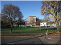
Nottingham Girls Academy, Robin's Wood Road, Aspley
Originally the Manning School for Girls, this became the first Nottingham all girls academy in 2011. Undergoing a substantial programme of new building further down the road.
Image: © Tim Heaton
Taken: 11 Nov 2012
0.18 miles
2
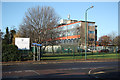
Nottingham Girls Academy
School on Robins Wood Road in Aspley
Image: © Richard Croft
Taken: 25 Nov 2011
0.19 miles
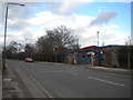
3

Rainbow day
Sunlight and showers at Aspley. The junction of Prestwood Drive with Robin's Wood Road.
Image: © Alan Murray-Rust
Taken: 25 Oct 2009
0.22 miles
4
Entrance to Government Buildings, Aspley
The entrance to the Chalfont Drive Government Buildings complex from Robin's Wood Road, Aspley. Security is high at this complex, although the site seems only to be used for relatively prosaic government functions; for example, it houses branches of the Driving Standards Agency and the Land Registry.
Image: © Richard Vince
Taken: 1 Feb 2013
0.23 miles
5
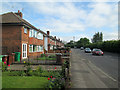
On Robins Wood Road
This is the Beechdale Road end of a road which links the Beechdale and Aspley Estates.
Image: © John Sutton
Taken: 13 May 2014
0.23 miles