IMAGES TAKEN NEAR TO
Aspley Park Drive, NOTTINGHAM, NG8 3EA
Introduction
This page details the photographs taken nearby to Aspley Park Drive, NG8 3EA by members of the Geograph project.
The Geograph project started in 2005 with the aim of publishing, organising and preserving representative images for every square kilometre of Great Britain, Ireland and the Isle of Man.

There are currently over 7.5m images from over14,400 individuals and you can help contribute to the project by visiting https://www.geograph.org.uk
Image Map
Images are licensed for reuse under creativecommons.org/licenses/by-sa/2.0
Notes
- Clicking on the map will re-center to the selected point.
- The higher the marker number, the further away the image location is from the centre of the postcode.
Image Listing (46 Images Found)
Images are licensed for reuse under creativecommons.org/licenses/by-sa/2.0
Image
Details
Distance
1
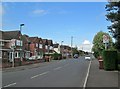
Aspley Park Drive
Part of the rapid westward expansion of the city either side of the Second World War. This consisted mostly of council housing, with some roads of private houses.
Image: © John Sutton
Taken: 13 May 2014
0.04 miles
2
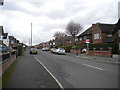
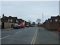
Aspley Park Drive, Aspley
Seen from its junction with Robin's Wood Road, this road is part of the suburban development south of Aspley Lane between Western Boulevard and the northern end of Beechdale estate.
Image: © Richard Vince
Taken: 1 Feb 2013
0.05 miles
3
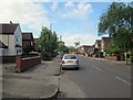
Aspley: Robins Wood Road
Part of the rapid westward expansion of the city either side of the Second World War. This consisted mostly of council housing, with some roads of private houses.
Image: © John Sutton
Taken: 13 May 2014
0.09 miles
4
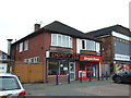
Chinese takeaway and shop on Aspley Lane, Aspley
Image: © JThomas
Taken: 27 Mar 2017
0.12 miles
5
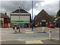
Supermarket and Saly Army
On Aspley Lane, Nottingham. At first glance I thought that the Co-op was in an old cinema. More probably this was a combination of non-conformist church and church-hall / Sunday school. The church is now the supermarket and the hall is now the Salvation Army.
Image: © David Lally
Taken: 18 Aug 2009
0.12 miles
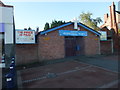
7
Aspley Pentecostal Church
This is on quite a different scale to the Methodist church opposite [http://www.geograph.org.uk/photo/911147].
Image: © Oxymoron
Taken: 6 Aug 2008
0.12 miles
8
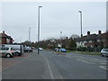
Robin's Wood Road, Aspley
Looking south west from Aspley Lane.
Image: © JThomas
Taken: 27 Mar 2017
0.12 miles
10
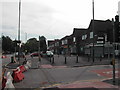
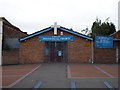
Post Office and Shops
located on Aspley Lane, Nottingham. The road that is closed off in Robin's Wood Road
Image: © Tom Courtney
Taken: 9 Sep 2005
0.13 miles