IMAGES TAKEN NEAR TO
Wroxham Drive, NOTTINGHAM, NG8 2QR
Introduction
This page details the photographs taken nearby to Wroxham Drive, NG8 2QR by members of the Geograph project.
The Geograph project started in 2005 with the aim of publishing, organising and preserving representative images for every square kilometre of Great Britain, Ireland and the Isle of Man.

There are currently over 7.5m images from over14,400 individuals and you can help contribute to the project by visiting https://www.geograph.org.uk
Image Map
Images are licensed for reuse under creativecommons.org/licenses/by-sa/2.0
Notes
- Clicking on the map will re-center to the selected point.
- The higher the marker number, the further away the image location is from the centre of the postcode.
Image Listing (43 Images Found)
Images are licensed for reuse under creativecommons.org/licenses/by-sa/2.0
Image
Details
Distance
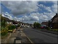
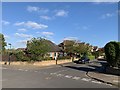
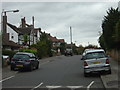
2
Wroxham Drive
Typical 1950s/60s suburban development.
Image: © Alan Murray-Rust
Taken: 6 Sep 2009
0.08 miles
3
Sheraton Drive
The area west of the Park was developed for housing between the wars.
Image: © Alan Murray-Rust
Taken: 19 Oct 2008
0.10 miles
4
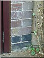
Bench mark, 137 Wollaton Vale
Close up view obtained courtesy of the owners.
Image: © Alan Murray-Rust
Taken: 18 Sep 2016
0.12 miles
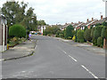
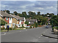
5
Junction of Wollaton Rise and Parkside Gardens
Housing from the 1950s.
Image: © Andrew Abbott
Taken: 6 May 2020
0.15 miles
6
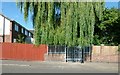
Access to the Tottle Brook on Woodbank Drive
The rather menacing fence and gate provides access for keeping the brook clear of debris which could otherwise result in flooding of adjacent properties.
Image: © Alan Murray-Rust
Taken: 18 Sep 2016
0.15 miles
7
Woodbank Drive
Typical 1950s/60s suburban development.
Image: © Alan Murray-Rust
Taken: 6 Sep 2009
0.15 miles
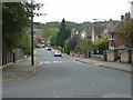
8
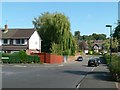
Woodbank Drive looking towards Wollaton Vale
The dip in the road marks the point at which it crosses the Tottle Brook http://www.geograph.org.uk/photo/5123314
This end of the road also forms part of the Robin Hood Way long distance footpath.
Image: © Alan Murray-Rust
Taken: 18 Sep 2016
0.15 miles
9
Parkside, Wollaton
The area west of the Park was developed for housing between the wars.
Image: © Alan Murray-Rust
Taken: 19 Oct 2008
0.16 miles
10
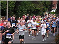
Nottingham Marathon 2004 in Parkside
Image: © Adrian Fairhurst
Taken: 12 Sep 2004
0.16 miles