IMAGES TAKEN NEAR TO
Cottage Walk, NOTTINGHAM, NG8 2DY
Introduction
This page details the photographs taken nearby to Cottage Walk, NG8 2DY by members of the Geograph project.
The Geograph project started in 2005 with the aim of publishing, organising and preserving representative images for every square kilometre of Great Britain, Ireland and the Isle of Man.

There are currently over 7.5m images from over14,400 individuals and you can help contribute to the project by visiting https://www.geograph.org.uk
Image Map
Images are licensed for reuse under creativecommons.org/licenses/by-sa/2.0
Notes
- Clicking on the map will re-center to the selected point.
- The higher the marker number, the further away the image location is from the centre of the postcode.
Image Listing (48 Images Found)
Images are licensed for reuse under creativecommons.org/licenses/by-sa/2.0
Image
Details
Distance
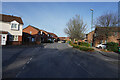
1
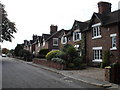
Houses, Bridge Road, Wollaton
These old cottages, now heavily gentrified, were once, I think, something to do with the old Nottingham canal, which used to run very close to here (hence, presumably, the name of the road - the nearest bridge now is over 1 kilometre away).
Image: © Oxymoron
Taken: 10 Oct 2008
0.03 miles
3
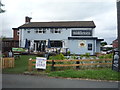
Middletons public house, Wollaton
On Trowell Road.
Image: © JThomas
Taken: 9 Jul 2016
0.07 miles
4
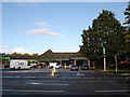
Trowell Road Co-op
Recently completely refurbished inside.
Image: © Oxymoron
Taken: 16 Oct 2008
0.10 miles
5
Torvill Drive
Torvill Drive is a long and meandering road to the north of Russell Drive. I presume it is named after the ice dancer who won an Olympic gold medal in the 1980's.
Image: © Malcolm Neal
Taken: 25 Nov 2021
0.10 miles
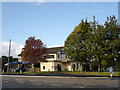
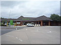
6

Wollaton Colliery Park and Ride Site
For some years in the 1970s this site - once occupied by Wollaton Colliery - was used for a park and ride scheme to Nottingham city centre. The weekday service operated only in the peaks, set up as part of the city's ill-fated 'zone and collar' traffic management scheme, and was little used, but the all-day Saturday operation, seen here, was popular. The site is now a Co-op superstore.
Image: © Stephen McKay
Taken: Unknown
0.11 miles
7
Waitrose supermarket, Wollaton
Off Trowell Road.
Image: © JThomas
Taken: 9 Jul 2016
0.11 miles
8
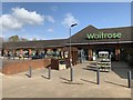
Waitrose at Wollaton
Just off Trowell Road.
Image: © Andrew Abbott
Taken: 31 Mar 2019
0.11 miles
9
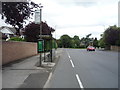
Bus stop and shelter on Russell Drive, Wollaton
Image: © JThomas
Taken: 9 Jul 2016
0.12 miles
10
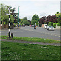
Wollaton: Doctor's Corner
Looking along the A609 Trowell Road in the Ilkeston direction from the junction of Wollaton Road (the original road through the village) and Russell Drive, built to bypass Wollaton in the 1930s.
Image: © John Sutton
Taken: 14 Jun 2013
0.12 miles