IMAGES TAKEN NEAR TO
Russell Drive, NOTTINGHAM, NG8 2BH
Introduction
This page details the photographs taken nearby to Russell Drive, NG8 2BH by members of the Geograph project.
The Geograph project started in 2005 with the aim of publishing, organising and preserving representative images for every square kilometre of Great Britain, Ireland and the Isle of Man.

There are currently over 7.5m images from over14,400 individuals and you can help contribute to the project by visiting https://www.geograph.org.uk
Image Map
Images are licensed for reuse under creativecommons.org/licenses/by-sa/2.0
Notes
- Clicking on the map will re-center to the selected point.
- The higher the marker number, the further away the image location is from the centre of the postcode.
Image Listing (110 Images Found)
Images are licensed for reuse under creativecommons.org/licenses/by-sa/2.0
Image
Details
Distance
1
A walk round Martin's Pond (15)
Russell Avenue from the gate into the Nature Reserve: the end of our walk.
See http://www.nottinghamcity.gov.uk/www/greenspaces/Docs/MartinsPondmap.pdf for a map of the site.
Previous image: Image
Image: © Kate Jewell
Taken: 11 Mar 2008
0.05 miles
2
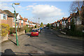
Russell Drive
Looking east towards Nottingham city centre along the A609, a busy exit route from Nottingham. This tree lined road looks very quiet at 4.30 pm but just you wait until 5 o'clock! The road to the left is Russell Avenue which gives access to Martin's Pond Nature Reserve: http://www.geograph.org.uk/photo/728288
Image: © Kate Jewell
Taken: 11 Mar 2008
0.07 miles
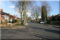
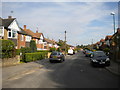
4
Russell Drive: waiting for the lights
City-bound cars waiting at the traffic lights on a bright May morning. Russell Drive bypasses Wollaton village.
Image: © John Sutton
Taken: 4 May 2016
0.09 miles
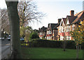
5
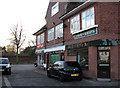
Russell Drive Shops
Wollaton Park wall is on the other side of the road.
Image: © John Sutton
Taken: 20 Nov 2009
0.10 miles
6
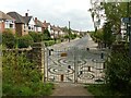
The entrance to Martin's Pond
The new gates were installed in July 2020; created with local children from Fernwood School and Artist Richard Janes.
Image: © Alan Murray-Rust
Taken: 3 Aug 2021
0.10 miles
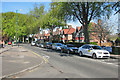
7
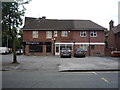
Wollaton Fish Bar
On Russell Drive, Wollaton.
Image: © JThomas
Taken: 9 Jul 2016
0.10 miles
9
A walk through Harrison's Plantation (2)
An overflow stream from Martin's Pond flows through Harrison's Plantation eventually feeding into the lake at Wollaton Park. The stream and the associated wetland is a breeding ground for toads, frogs and newts as well as attracting many types of bird. See http://www.wildlifetrust.org.uk/nottinghamshire/reserves/Harrison's%20Plantation.htm
Previous image Image, next image Image
Image: © Kate Jewell
Taken: 11 Mar 2008
0.10 miles
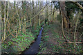
10

A walk through Harrison's Plantation (3)
The stream from the outflow of Martin's Pond meanders through the trees providing a damp environment for frogs and toads. Thought to be the site of medieval stew ponds linking Martin's Pond and Raleigh Pond the Nature Reserve is managed by the Nottinghamshire Wildlife Trust for the owners, Nottingham City Council. See http://www.wildlifetrust.org.uk/nottinghamshire/reserves/Harrison's%20Plantation.htm
Previous image Image, next image Image
Image: © Kate Jewell
Taken: 11 Mar 2008
0.10 miles