IMAGES TAKEN NEAR TO
Wollaton Hall, NOTTINGHAM, NG8 2AE
Introduction
This page details the photographs taken nearby to Wollaton Hall, NG8 2AE by members of the Geograph project.
The Geograph project started in 2005 with the aim of publishing, organising and preserving representative images for every square kilometre of Great Britain, Ireland and the Isle of Man.

There are currently over 7.5m images from over14,400 individuals and you can help contribute to the project by visiting https://www.geograph.org.uk
Image Map
Images are licensed for reuse under creativecommons.org/licenses/by-sa/2.0
Notes
- Clicking on the map will re-center to the selected point.
- The higher the marker number, the further away the image location is from the centre of the postcode.
Image Listing (319 Images Found)
Images are licensed for reuse under creativecommons.org/licenses/by-sa/2.0
Image
Details
Distance
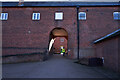
1
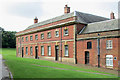
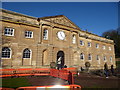
Wollaton Hall: a side of the stables
"Stables and offices were built away from the house in 1794. Plain red brick block with stone S front" (Nikolaus Pevsner). Image] shows the grand frontage. Image] is another view of this elevation of the building.
Image: © John Sutton
Taken: 14 Jun 2013
0.00 miles
2
Wollaton Hall stable block
The former stables of the impressive Elizabethan mansion Image now house an industrial museum and visitor facilities. And a clock that will be correct during British Summer Time !
Image: © Graham Hogg
Taken: 10 Mar 2014
0.00 miles
3
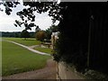
Pathway near the stable block, Wollaton Hall
This and its associated elements, including water trough https://www.geograph.org.uk/photo/7319052 and ice house https://www.geograph.org.uk/photo/7319054 , are part of Wyatville's improvements of the 1820s, Listed Grade II. The path is steeply inclined and the bricks are set at an angle forming ridges to give grip to climbing horses.
Image: © Alan Murray-Rust
Taken: 18 Oct 2022
0.01 miles
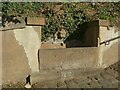
4
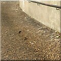
Retaining wall below the ice house near the stable block, Wollaton Hall
This and its associated elements, including water trough https://www.geograph.org.uk/photo/7319052 and brick path https://www.geograph.org.uk/photo/7319050 , are part of Wyatville's improvements of the 1820s, Listed Grade II. The icehouse is built into the slope under the trees.
Image: © Alan Murray-Rust
Taken: 18 Oct 2022
0.01 miles
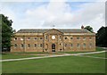
5
The stable block at Wollaton
This brick built series of buildings, formerly the stable block, houses an Industrial Museum, open only at the weekends, as well as a shop and cafe.
Image: © Malcolm Neal
Taken: 4 Nov 2022
0.01 miles
6
Water trough near the stable block, Wollaton Hall
This and its associated elements, including brick path https://www.geograph.org.uk/photo/7319050 and ice house https://www.geograph.org.uk/photo/7319054 , are part of Wyatville's improvements of the 1820s, Listed Grade II.
Image: © Alan Murray-Rust
Taken: 18 Oct 2022
0.01 miles
7
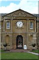
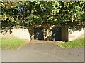
Entrance to Wollaton Hall Stable Block
The clock is actually showing the correct time.
Image: © Oxymoron
Taken: 12 Aug 2008
0.02 miles
8
Wollaton Hall stables
This grand elevation (1794) is in stone. The sides and rear, not so visible from the Hall, are brick. The stables now house Nottingham's industrial museum. Before that they were the home of the City Police Force horses.
Image: © John Sutton
Taken: 14 Jun 2013
0.02 miles
9
Wollaton Hall
Stable block Wollaton Hall Nottingham
Image: © norman griffin
Taken: 19 Sep 2017
0.02 miles
10
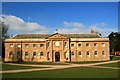
Part of Wollaton Hall, Nottingham
Classical Georgian by the look of it.
Image: © Jeremy Bolwell
Taken: 19 Jan 2020
0.02 miles