IMAGES TAKEN NEAR TO
Western Boulevard, NOTTINGHAM, NG8 1PE
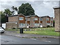
Introduction
This page details the photographs taken nearby to Western Boulevard, NG8 1PE by members of the Geograph project.
The Geograph project started in 2005 with the aim of publishing, organising and preserving representative images for every square kilometre of Great Britain, Ireland and the Isle of Man.

There are currently over 7.5m images from over14,400 individuals and you can help contribute to the project by visiting https://www.geograph.org.uk
Image Map
Images are licensed for reuse under creativecommons.org/licenses/by-sa/2.0
Notes
- Clicking on the map will re-center to the selected point.
- The higher the marker number, the further away the image location is from the centre of the postcode.
Image Listing (92 Images Found)
Images are licensed for reuse under creativecommons.org/licenses/by-sa/2.0
Image
Details
Distance
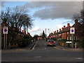
1

Western Boulevard
The Nottingham Ring Road just north of Crown Island
Image: © Alan Murray-Rust
Taken: 19 Oct 2008
0.01 miles
2
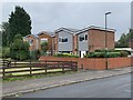
Houses on Radford Bridge Road
Dating from the 1970s and built on an old allotment site.
Image: © Andrew Abbott
Taken: 23 Aug 2020
0.05 miles
4
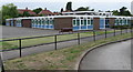
Southwold Primary School, Radford
Southwold Primary School was built in 1968 to serve the local council housing. Many people in the area then worked for Raleigh or Players. Formerly it was known as Wollaton Board School and was located where the University's Jubilee Campus is now sited. The school now serves a rich and diverse community with a range of cultures.
Image: © Sally Holmes
Taken: 1 Aug 2006
0.06 miles
5
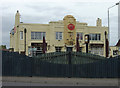
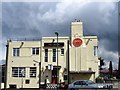
Crown Hotel
Art deco pub on the corner of Trowell Road and Western Boulevard. It still retains the former Home Ales name in the stucco.
Image: © Alan Murray-Rust
Taken: 19 Oct 2008
0.07 miles
6
Houses on Radford Bridge Road
Built in the 1970s.
Image: © Andrew Abbott
Taken: 23 Aug 2020
0.07 miles
7
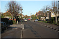
Radford Bridge Road
NCN route 6 on Radford Bridge Road
Image: © Richard Croft
Taken: 25 Nov 2011
0.08 miles
8
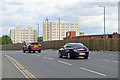
Round Wollaton Road roundabouts
In the background are the two remaining blocks of the old Player's Bonded Warehouse. Demolition began in June 2017. The site will be redeveloped as an extension of Nottingham University's Jubilee Campus. The cars are in the centre lane, so are probably heading for the city up Ilkeston Road.
Image: © John Sutton
Taken: 24 Aug 2017
0.08 miles
9
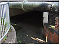
Wollaton Road subway
Although this is now a route for pedestrians and cyclists to avoid negotiating the traffic that constantly swirls round the busy junction above, it was originally a canal bridge - and is one of the few remaining structures of the Nottingham Canal north of Lenton Junction within the Nottingham suburbs.
Image: © Stephen McKay
Taken: 4 Jul 2008
0.09 miles
10
Marchwood Close, off Wollaton Road
Typical Nottingham council houses.
Image: © John Sutton
Taken: 20 Nov 2009
0.09 miles