IMAGES TAKEN NEAR TO
Hillsford Close, NOTTINGHAM, NG8 1JH
Introduction
This page details the photographs taken nearby to Hillsford Close, NG8 1JH by members of the Geograph project.
The Geograph project started in 2005 with the aim of publishing, organising and preserving representative images for every square kilometre of Great Britain, Ireland and the Isle of Man.

There are currently over 7.5m images from over14,400 individuals and you can help contribute to the project by visiting https://www.geograph.org.uk
Image Map
Images are licensed for reuse under creativecommons.org/licenses/by-sa/2.0
Notes
- Clicking on the map will re-center to the selected point.
- The higher the marker number, the further away the image location is from the centre of the postcode.
Image Listing (41 Images Found)
Images are licensed for reuse under creativecommons.org/licenses/by-sa/2.0
Image
Details
Distance
1
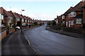
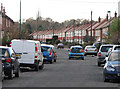
Charlbury Road - Nottingham
Looking East towards the centre of Nottingham which lies on the other side of the hill in the far distance. The blocks of flats just visible are in Radford and seen in this picture Image
Image: © David Lally
Taken: 29 Nov 2007
0.07 miles
3
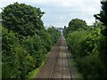
East from Woodyard Lane railway bridge
Since John Sutton took this view https://www.geograph.org.uk/photo/2473446 in 2011, some of the blocks of flats in the distance have been demolished and there has been considerable tree growth alongside the railway.
Image: © Alan Murray-Rust
Taken: 3 Aug 2021
0.11 miles
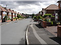
4
Wollaton: up Elvaston Road
Looking west towards Brendon Road on a November afternoon. This part of Nottingham was developed in the years either side of the Second World War.
Image: © John Sutton
Taken: 20 Nov 2009
0.11 miles
6
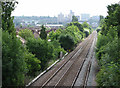
East from Woodyard Lane railway bridge
The line from Radford Junction (ahead) to Trowell, on the Erewash Valley Line, was built as a short cut for trains to and from the north, avoiding the bottleneck at Toton; it also served Wollaton Colliery. This is the view back towards the city, with some of the rooftops of Beechdale Estate on the left and Radford and its high-rise flats on the skyline. Years ago that skyline was dominated by Players cigarette factory, long demolished. The bridge over the railway just visible in the distance carries Western Boulevard.
Image: © John Sutton
Taken: 22 Jun 2011
0.12 miles
7

Radford to Trowell Railway
In Bilborough. Opened in 1875 by the Midland Railway.
Image: © Andrew Abbott
Taken: 3 Jul 2021
0.14 miles
8
Woodyard Lane
Originally a country lane, this is still a pedestrian route through from Wollaton to Bilborough. This end also provides vehicle access to a factory.
Image: © Alan Murray-Rust
Taken: 19 Oct 2008
0.16 miles
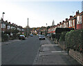
9
Woodyard Lane - the Wollaton End
This bridleway links Wollaton and the Beechdale Estate. Fifty years or more ago, this was a good place for eleven-year-olds: you could collect engine numbers from the bridge over the Radford-Trowell line at the top of the slope ahead, or fish for newts in the canal, which the lane had once crossed just behind the camera. The Nottingham Canal north of Lenton was abandoned in 1937, but its course and the decaying locks were not cleared away in these parts until the 1980s. Torvill Close - named for Nottingham's Olympic ice-skating champion - parallels its course. Alan Murray-Rust's photos, including Image] and Image], show what little remains of the canal in Wollaton.
Image: © John Sutton
Taken: 22 Jun 2011
0.17 miles
10
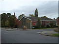
Kingswood Methodist Church
Simple but effective architecture from the post-war period.
Image: © Alan Murray-Rust
Taken: 19 Oct 2008
0.17 miles