IMAGES TAKEN NEAR TO
Wollaton Road, NOTTINGHAM, NG8 1GQ
Introduction
This page details the photographs taken nearby to Wollaton Road, NG8 1GQ by members of the Geograph project.
The Geograph project started in 2005 with the aim of publishing, organising and preserving representative images for every square kilometre of Great Britain, Ireland and the Isle of Man.

There are currently over 7.5m images from over14,400 individuals and you can help contribute to the project by visiting https://www.geograph.org.uk
Image Map
Images are licensed for reuse under creativecommons.org/licenses/by-sa/2.0
Notes
- Clicking on the map will re-center to the selected point.
- The higher the marker number, the further away the image location is from the centre of the postcode.
Image Listing (82 Images Found)
Images are licensed for reuse under creativecommons.org/licenses/by-sa/2.0
Image
Details
Distance
1
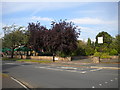
Trees hiding a pub
The pub called the Wollaton, located in Wollaton, is hidden from the south end of Lambourne Drive by trees, hence the rather isolated pub sign in a small open space visible on the right.
Image: © Richard Vince
Taken: 15 Sep 2012
0.01 miles

3
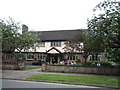
The Wollaton public house
On Lambourne Drive.
Image: © JThomas
Taken: 9 Jul 2016
0.02 miles
4

The Foot Room
Chiropodist on Lambourne Drive, Wollaton
Image: © JThomas
Taken: 9 Jul 2016
0.02 miles
5
Wollaton: The Wollaton
This pub on the corner of Lambourne Drive was originally The Willoughby Arms, a Kimberley Brewery house.
Image: © John Sutton
Taken: 4 May 2016
0.02 miles
6

Lambourne Drive: The Wollaton
This was originally The Willoughby Arms, a Kimberley house - see Alan Murray-Rust's Image], taken a year before this picture.
Image: © John Sutton
Taken: 20 Nov 2009
0.02 miles
7
Willoughby Arms
Post-war pub on Wollaton Road.
Image: © Alan Murray-Rust
Taken: 19 Oct 2008
0.04 miles
8
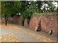
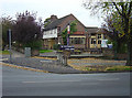
Old park wall alongside Wollaton Road
When the eastern part of Wollaton Park was sold off for housing, the section of the park boundary wall along Wollaton Road was retained. Much of it dates back to the late 18th century. The wall is broken into three sections by the construction of Ancaster Gardens and Eton Grove, each Listed Grade II separately. This is part of the section between Cambridge Road and Ancaster Gardens.
Image: © Alan Murray-Rust
Taken: 12 Sep 2021
0.04 miles
9
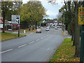
Wollaton Road
Looking towards the junction with Russell Drive. The route through Wollaton Village was formerly the main road to Ilkeston.
Image: © Alan Murray-Rust
Taken: 19 Oct 2008
0.04 miles
10
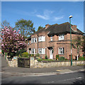
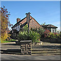
Wollaton: Derbyshire Corner
The plaque in the garden reads "In accordance with the will of Lucy Derbyshire who died on the 22nd February 1946 these five homes of rest were erected by her executors. December 1951".
Image: © John Sutton
Taken: 4 May 2016
0.06 miles