IMAGES TAKEN NEAR TO
Ellwood Crescent, NOTTINGHAM, NG8 1GD
Introduction
This page details the photographs taken nearby to Ellwood Crescent, NG8 1GD by members of the Geograph project.
The Geograph project started in 2005 with the aim of publishing, organising and preserving representative images for every square kilometre of Great Britain, Ireland and the Isle of Man.

There are currently over 7.5m images from over14,400 individuals and you can help contribute to the project by visiting https://www.geograph.org.uk
Image Map
Images are licensed for reuse under creativecommons.org/licenses/by-sa/2.0
Notes
- Clicking on the map will re-center to the selected point.
- The higher the marker number, the further away the image location is from the centre of the postcode.
Image Listing (94 Images Found)
Images are licensed for reuse under creativecommons.org/licenses/by-sa/2.0
Image
Details
Distance
1
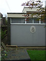
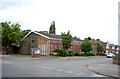
Wollaton telephone exchange
The royal cipher shows that it was built when the telephone network still came under the Post Office.
Image: © Alan Murray-Rust
Taken: 19 Oct 2008
0.04 miles
2
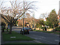
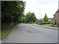
Lambourne Drive, Wollaton
Kingswood Methodist Church is behind the cars, on the corner of Elvaston Road.
Image: © John Sutton
Taken: 20 Nov 2009
0.04 miles
3
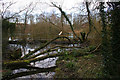
A walk through Harrison's Plantation (8)
The footpath through Harrison's Plantation circumnavigates Raleigh Pond along the top of the bank round this old claypit. This view shows the foot bridge which carries the lower waterside path across the marshy outflow to the south east. See http://www.wildlifetrust.org.uk/nottinghamshire/reserves/Harrison's%20Plantation.htm
Finish the walk by following the footpath east to the gate on Lambourne Drive.
Previous image Image
Image: © Kate Jewell
Taken: 11 Mar 2008
0.04 miles
4
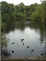
Raleigh Pond
Within Harrison's Plantation, and fed, not as many people think, by the overflow from Martins Pond, but by an underground spring. Thought originally to be a clay pit.
Image: © Alan Murray-Rust
Taken: 19 Oct 2008
0.05 miles
5
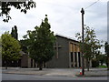
Kingswood Methodist Church
On Lambourne Drive, Wollaton.
Image: © JThomas
Taken: 9 Jul 2016
0.05 miles
7
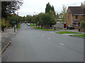
Lambourne Drive
Built as part of the residential development of Wollaton just before the second World War, it was a dead end until the development of the Lambourne Drive/Torvill Drive area.
Image: © Alan Murray-Rust
Taken: 19 Oct 2008
0.05 miles
9
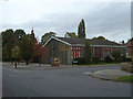
Kingswood Methodist Church
Simple but effective architecture from the post-war period.
Image: © Alan Murray-Rust
Taken: 19 Oct 2008
0.06 miles
10
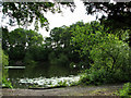
Raleigh Pond
A flooded claypit which is part of the Harrison's Plantation Nature Reserve.
Image: © John Sutton
Taken: 22 Jun 2011
0.06 miles