IMAGES TAKEN NEAR TO
Harrow Road, NOTTINGHAM, NG8 1FG
Introduction
This page details the photographs taken nearby to Harrow Road, NG8 1FG by members of the Geograph project.
The Geograph project started in 2005 with the aim of publishing, organising and preserving representative images for every square kilometre of Great Britain, Ireland and the Isle of Man.

There are currently over 7.5m images from over14,400 individuals and you can help contribute to the project by visiting https://www.geograph.org.uk
Image Map
Images are licensed for reuse under creativecommons.org/licenses/by-sa/2.0
Notes
- Clicking on the map will re-center to the selected point.
- The higher the marker number, the further away the image location is from the centre of the postcode.
Image Listing (62 Images Found)
Images are licensed for reuse under creativecommons.org/licenses/by-sa/2.0
Image
Details
Distance
1

Footpath near Hawton Spinney
The 'no vehicles' sign seems slightly superfluous in view of the street furniture!
Image: © Alan Murray-Rust
Taken: 19 Oct 2008
0.01 miles
2
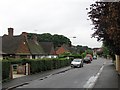
A wet morning in Sutton Passeys Crescent
The estate, largely of bungalows, either side of Middleton Boulevard was built in the late 1920s. In the middle ages Sutton Passeys was a village, part of the parish of Radford, but it was lost when Wollaton Park was enclosed. The copse showing above the roofs on the left is Hawton Spinney.
Image: © John Sutton
Taken: 20 Jul 2012
0.04 miles
3

Wollaton Park Medical Centre
From Harrow Road.
Image: © Andrew Abbott
Taken: 3 Jun 2020
0.04 miles
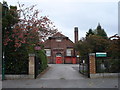
5

Wollaton Park Medical Centre
This is a new(ish) building, only open for a few months at the time of taking the photo (the previous building was completely destroyed by fire).
Image: © Oxymoron
Taken: 30 Oct 2008
0.05 miles
6
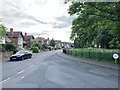
Hawton Spinney, Wollaton
At the junction with Sutton Passeys Crescent
Image: © Andrew Abbott
Taken: 19 May 2020
0.07 miles
7

Hawton Spinney
A small stand of woodland incorporated into the Wollaton Park Estate when it was built, with a circular roadway round it. On the north side can be seen one of the traditional circular Nottingham road name signs.
Image: © Alan Murray-Rust
Taken: 19 Oct 2008
0.07 miles
8

Hawton Spinney and Sutton Passeys Crescent in the rain
The estate, largely of bungalows, either side of Middleton Boulevard was built in the late 1920s. In the middle ages Sutton Passeys was a village, part of the parish of Radford, but it was lost when Wollaton Park was enclosed. The roads retain the distinctive circular signs the City once used on all of its council estates.
Image: © John Sutton
Taken: 20 Jul 2012
0.08 miles
9

Shops at Crown Island
A local shopping parade which still retains a higher than usual number of non-fast-food retail outlets, including a small supermarket, Post Office, and baker.
Image: © Alan Murray-Rust
Taken: 19 Oct 2008
0.08 miles
10

Hawton Spinney
A small stand of woodland incorporated into the Wollaton Park Estate when it was built, with a circular roadway round it.
Image: © Alan Murray-Rust
Taken: 19 Oct 2008
0.08 miles