IMAGES TAKEN NEAR TO
Hawton Crescent, NOTTINGHAM, NG8 1ED
Introduction
This page details the photographs taken nearby to Hawton Crescent, NG8 1ED by members of the Geograph project.
The Geograph project started in 2005 with the aim of publishing, organising and preserving representative images for every square kilometre of Great Britain, Ireland and the Isle of Man.

There are currently over 7.5m images from over14,400 individuals and you can help contribute to the project by visiting https://www.geograph.org.uk
Image Map
Images are licensed for reuse under creativecommons.org/licenses/by-sa/2.0
Notes
- Clicking on the map will re-center to the selected point.
- The higher the marker number, the further away the image location is from the centre of the postcode.
Image Listing (40 Images Found)
Images are licensed for reuse under creativecommons.org/licenses/by-sa/2.0
Image
Details
Distance
1
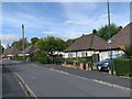
Hawton Crescent, Wollaton
Bungalows built on former Wollaton Park land.
Image: © Andrew Abbott
Taken: 19 May 2020
0.02 miles
2

Broughton Drive
Typical road in the Wollaton Park Estate.
Image: © Alan Murray-Rust
Taken: 19 Oct 2008
0.07 miles
3
Hawton Crescent, Wollaton
At the junction with Broughton Drive.
Image: © Andrew Abbott
Taken: 19 May 2020
0.07 miles
4
Hawton Spinney, Wollaton
At the junction with Hawton Crescent.
Image: © Andrew Abbott
Taken: 19 May 2020
0.08 miles
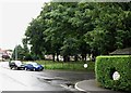
5

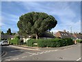
Hawton Spinney
A small stand of woodland incorporated into the Wollaton Park Estate when it was built, with a circular roadway round it.
Image: © Alan Murray-Rust
Taken: 19 Oct 2008
0.09 miles
6
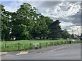
Sutton Passeys Crescent
A pleasant suburban road on the eastern edge of Wollaton Park.
Image: © David Lally
Taken: 9 Oct 2008
0.10 miles
7
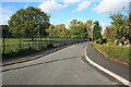
Hawton Spinney and Sutton Passeys Crescent in the rain
The estate, largely of bungalows, either side of Middleton Boulevard was built in the late 1920s. In the middle ages Sutton Passeys was a village, part of the parish of Radford, but it was lost when Wollaton Park was enclosed. The roads retain the distinctive circular signs the City once used on all of its council estates.
Image: © John Sutton
Taken: 20 Jul 2012
0.10 miles
8
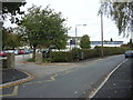
Bluecoat School
This site adjacent to Wollaton Park was formerly the Margaret Glen Bott School.
Image: © Alan Murray-Rust
Taken: 19 Oct 2008
0.10 miles
9

Hawton Spinney
A small stand of woodland incorporated into the Wollaton Park Estate when it was built, with a circular roadway round it. On the north side can be seen one of the traditional circular Nottingham road name signs.
Image: © Alan Murray-Rust
Taken: 19 Oct 2008
0.10 miles
10
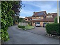
Abbots Way, Wollaton
Off Harrow Gardens
Image: © Andrew Abbott
Taken: 19 May 2020
0.10 miles