IMAGES TAKEN NEAR TO
Oundle Drive, NOTTINGHAM, NG8 1BN
Introduction
This page details the photographs taken nearby to Oundle Drive, NG8 1BN by members of the Geograph project.
The Geograph project started in 2005 with the aim of publishing, organising and preserving representative images for every square kilometre of Great Britain, Ireland and the Isle of Man.

There are currently over 7.5m images from over14,400 individuals and you can help contribute to the project by visiting https://www.geograph.org.uk
Image Map
Images are licensed for reuse under creativecommons.org/licenses/by-sa/2.0
Notes
- Clicking on the map will re-center to the selected point.
- The higher the marker number, the further away the image location is from the centre of the postcode.
Image Listing (88 Images Found)
Images are licensed for reuse under creativecommons.org/licenses/by-sa/2.0
Image
Details
Distance
1
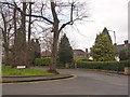
Adams Hill
Paralleling Derby Road, this is a development of prestige detached houses from the Inter-war period in what was originally part of Wollaton Park.
Image: © Alan Murray-Rust
Taken: 9 Feb 2014
0.07 miles
2
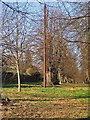
Curious metal pole, Lime Tree Avenue
This rather rusty metal post lies near the east end of Lime Tree Avenue just behind houses on Lanark Close. I have no idea as to its purpose, but have been intrigued by it ever since I first noticed it.
Image: © SK53
Taken: 15 Feb 2005
0.08 miles
3
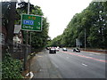
Derby 14 Miles
The A52 heading west from Nottingham.
Image: © JThomas
Taken: 9 Jul 2016
0.08 miles
4

1 Middleton Boulevard, Wollaton
House dating from the 1930s
Image: © Andrew Abbott
Taken: 19 May 2020
0.08 miles
6
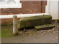
Fallen gatepost at Lenton Firs Lodge (East)
Note the bench mark on the side of the gatepost. This was used during the first Ordnance Survey primary levelling of 1840-60 as part of the Widmerpool to Derby line http://www.bench-marks.org.uk/bm20212 . See http://www.geograph.org.uk/photo/3843941 for location.
Image: © Alan Murray-Rust
Taken: 9 Feb 2014
0.08 miles
7
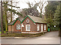
Lenton Firs Lodge
This was indeed the lodge to Lenton Firs - cf the other 'Lenton Firs Lodge' http://www.geograph.org.uk/photo/3843934. The paper stickers in the windows proclaim it to be Lenton Firs Lodge East. The building has clearly been extended twice since it was built in 1861 http://www.geograph.org.uk/photo/3843942.
Note the fallen gatepost in front of the former entrance, which has been lying there since at least 2009, see http://www.geograph.org.uk/photo/3843940
Image: © Alan Murray-Rust
Taken: 9 Feb 2014
0.09 miles
8
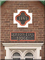
Lenton Firs Lodge (detail)
Date stone and name panel on the Derby Road façade. See http://www.geograph.org.uk/photo/3843941
Image: © Alan Murray-Rust
Taken: 9 Feb 2014
0.09 miles
9
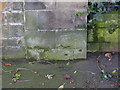
Bench Mark, Wollaton Park entrance on Middleton Boulevard
See http://www.geograph.org.uk/photo/3852477 for location.
Image: © Alan Murray-Rust
Taken: 16 Feb 2014
0.10 miles
10
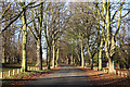
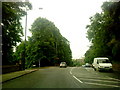
Lime Tree Avenue
Avenue from Middleton Boulevard to Wollaton Park Golf Club
Image: © Richard Croft
Taken: 25 Nov 2011
0.10 miles