IMAGES TAKEN NEAR TO
Fairham Drive, NOTTINGHAM, NG8 1AL
Introduction
This page details the photographs taken nearby to Fairham Drive, NG8 1AL by members of the Geograph project.
The Geograph project started in 2005 with the aim of publishing, organising and preserving representative images for every square kilometre of Great Britain, Ireland and the Isle of Man.

There are currently over 7.5m images from over14,400 individuals and you can help contribute to the project by visiting https://www.geograph.org.uk
Image Map
Images are licensed for reuse under creativecommons.org/licenses/by-sa/2.0
Notes
- Clicking on the map will re-center to the selected point.
- The higher the marker number, the further away the image location is from the centre of the postcode.
Image Listing (69 Images Found)
Images are licensed for reuse under creativecommons.org/licenses/by-sa/2.0
Image
Details
Distance
1
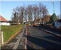
Cycle Route 6 on Orston Drive
This and neighbouring streets are part of the Sutton Passeys Conservation Area. This was social housing, mainly bungalows built in the 1920s using novel methods of metal frames and cast concrete, with a layout following the Garden City Movement. http://www.nottinghamcity.gov.uk/CHttpHandler.ashx?id=25587&p=0
Image: © Tim Heaton
Taken: 11 Nov 2012
0.05 miles
2
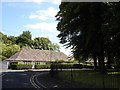
Junction of Orston and Fairham Drives in Wollaton, Nottingham
This photo was taken from the roundabout at the junction of Orston and Fairham Drives in Wollaton, Nottingham. The two semi-detached bungalows are absolutely typical of the housing in the small, pleasant area either side of Middleton Boulevard (also known as the ring road). The view looks towards the back of the Jubilee campus of Nottingham University (built on the site of the old Raleigh Factory), but the only part visible in this image (just above the tree-line in the middle of the photo) is the very top of the new Aspire sculpture [(http://aspire.nottingham.ac.uk/)]; the photo was taken about 10 days after the sculpture was erected.
Image: © Oxymoron
Taken: 4 Jul 2008
0.05 miles
3
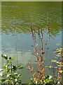
On the Jubilee campus
Alongside the main pond, post-flowering spikes of Purple loosestrife (Lythrum salicaria).
Image: © Alan Murray-Rust
Taken: 18 Oct 2022
0.13 miles
4
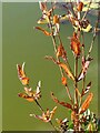
Autumn leaves, October 2022 ? 8
Post-flowering spikes of Purple loosestrife (Lythrum salicaria), by the pond on the Jubilee Campus.
Image: © Alan Murray-Rust
Taken: 18 Oct 2022
0.13 miles
5
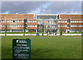
Jubilee Campus - visitors are welcome
The University takes an enlightened view of allowing the public to roam the campus, although it would be difficult to enclose it due to the number of rights of way which traverse it.
The building is the National College for School Leadership.
Image: © Alan Murray-Rust
Taken: 16 Feb 2014
0.14 miles
6
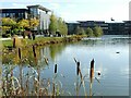
Architectural studies, Jubilee Campus, October 2022 ? 13
View across the pond to the Contemporary Chinese Studies building (left) and the conference Centre (right).
Image: © Alan Murray-Rust
Taken: 18 Oct 2022
0.14 miles
7
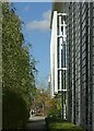
Architectural studies, Jubilee Campus, October 2022 ? 9
Contemporary Chinese Studies building on the right.
Image: © Alan Murray-Rust
Taken: 18 Oct 2022
0.14 miles
8
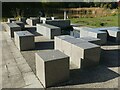
Architectural studies, Jubilee Campus, October 2022 ? 11
Granite seating blocks with pool, near the South Auditorium.
This forms the western end of the linear feature called The Boulevard https://www.geograph.org.uk/photo/3853154
Image: © Alan Murray-Rust
Taken: 18 Oct 2022
0.15 miles
9
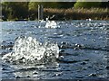
Architectural studies, Jubilee Campus, October 2022 ? 10
Water feature adjacent to the South Auditorium.
Image: © Alan Murray-Rust
Taken: 18 Oct 2022
0.15 miles
10

Architectural studies, Jubilee Campus, October 2022 ? 12
Detail of the South Auditorium.
Image: © Alan Murray-Rust
Taken: 18 Oct 2022
0.15 miles