IMAGES TAKEN NEAR TO
Beech Avenue, NOTTINGHAM, NG7 7LJ
Introduction
This page details the photographs taken nearby to Beech Avenue, NG7 7LJ by members of the Geograph project.
The Geograph project started in 2005 with the aim of publishing, organising and preserving representative images for every square kilometre of Great Britain, Ireland and the Isle of Man.

There are currently over 7.5m images from over14,400 individuals and you can help contribute to the project by visiting https://www.geograph.org.uk
Image Map
Images are licensed for reuse under creativecommons.org/licenses/by-sa/2.0
Notes
- Clicking on the map will re-center to the selected point.
- The higher the marker number, the further away the image location is from the centre of the postcode.
Image Listing (171 Images Found)
Images are licensed for reuse under creativecommons.org/licenses/by-sa/2.0
Image
Details
Distance
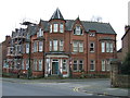
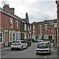
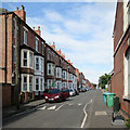
1
Beech Avenue - looking west
The northern edge of Forest Fields, where it shades into New Basford. The typical three-storey terraced houses, seen from the Sherwood Rise end of the road, date, like much of the area, from the end of the 19th century.
Image: © John Sutton
Taken: 27 Apr 2011
0.01 miles
2
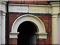
Beech Avenue: unnecessary apostrophe
Mendacious politicians and journalists would have you believe misuse of the apostrophe is the result of comprehensive education and the teaching methods of the 1960s and 70s – but anyone with eyes to see and a small grasp of history will know that confusion about its correct use has been endemic for much longer, as this nicely-carved piece dating from the late Victorian period shows.
Image: © John Sutton
Taken: 27 Apr 2011
0.01 miles
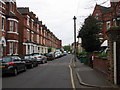
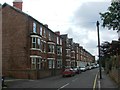
3
Beech Avenue - looking east
The northern edge of Forest Fields, where it shades into New Basford. The typical three-storey terraced houses at this end of the road date, like much of the area, from the end of the 19th century. This is the view towards Sherwood Rise.
Image: © John Sutton
Taken: 27 Apr 2011
0.02 miles
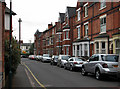
4
Sherwood Rise: Alma Street and Beech Avenue
In an area of red-brick terraces, the stone house on the corner is the exception.
Image: © John Sutton
Taken: 7 Sep 2016
0.02 miles
5
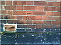
Benchmark on Londis Shop, Beech Road
This Ordnance Survey cut mark benchmark is actually above the pavement of Alma Street and is described on the Bench Mark Database at http://www.bench-marks.org.uk/bm35132
Image: © Roger Templeman
Taken: 10 Aug 2010
0.03 miles
6
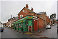
Londis corner shop
The shop is at the junction of Beech Avenue and Alma Street (on the right). There is an OS benchmark Image on the Alma Street face.
Image: © Roger Templeman
Taken: 9 Apr 2012
0.03 miles
8
Sherwood Rise: Alberta Terrace
Looking from Sherwood Rise towards Gladstone Street and Forest Fields. Any number of houses of this kind were built as Nottingham mushroomed in the last twenty years of the nineteenth century.
Image: © John Sutton
Taken: 6 Jul 2015
0.04 miles
9
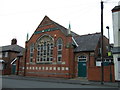
Madni Masjid and Muslims Education Centre
On Alberta Terrace, Forest Fields, City of Nottingham.
Image: © JThomas
Taken: 27 Mar 2017
0.05 miles