1
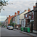
Gawthorne Street: The Pelham
Looking down from the crest of the ridge which divides New Basford (ahead) from Forest Fields.
Image: © John Sutton
Taken: 27 Sep 2013
0.01 miles
2
Gawthorne Street
Houses in New Basford which are typical of those built following the expansion of the Borough of Nottingham in 1877.
Image: © John Sutton
Taken: 27 Sep 2013
0.04 miles
3
Gawthorne Street houses
Ordnance Survey records indicate that a benchmark levelled at 70.598m above Newlyn Datum was verified in 1962 on #52 at its junction with #54
Image: © Roger Templeman
Taken: 4 Nov 2017
0.04 miles
4
South-west from Duke Street
A view over some of Nottingham's western suburbs from the ridge which marks the border between Forest Fields and New Basford. Wollaton Hall is on the skyline to the left, the hills beyond Bilborough and Strelley in the centre.
Image: © John Sutton
Taken: 27 Sep 2013
0.10 miles
5
Palmerston House (Mount Street Mill)
A former hosiery factory converted to offices. The building is advertised as suitable for educational as well as commercial use.
Image: © John Sutton
Taken: 27 Apr 2011
0.12 miles
6
Mount Street
The former Mount Street Mill is now Middlesex International College, which specialises in commercial diploma courses. The building is on the crest of the ridge which separates Sherwood Rise, Forest Fields and Hyson Green (ahead) from New Basford.
Image: © John Sutton
Taken: 27 Sep 2013
0.12 miles
7
Performers at "The Stuff of Life" festival
A locally organised festival centred on Hedley Villas Park.
Image: © David Lally
Taken: 14 Sep 2019
0.13 miles
8
Guy Birkin Place Business Park, Beech Avenue
Once a lace factory owned by the Birkin family, whose wealth (and acquisition of the land) led to the development of Forest Fields as a genteel suburb, this is now let as offices, with permission for educational use.
Image: © John Sutton
Taken: 27 Apr 2011
0.13 miles
9
Birkin factory now derelict
Unoccupied and with many windows broken. For an earlier view, in the other direction, see
Image
Image: © John Sutton
Taken: 7 Sep 2016
0.13 miles
10
Villa on Beech Avenue
Most of Forest Fields dates from the last years of the Victorian era and the early part of the twentieth century, but this rather grand stuccoed villa probably dates from shortly after the Enclosure Act of 1845 which led to the rapid expansion of the city.
Image: © John Sutton
Taken: 27 Apr 2011
0.14 miles


