IMAGES TAKEN NEAR TO
Palm Court, NOTTINGHAM, NG7 7HU
Introduction
This page details the photographs taken nearby to Palm Court, NG7 7HU by members of the Geograph project.
The Geograph project started in 2005 with the aim of publishing, organising and preserving representative images for every square kilometre of Great Britain, Ireland and the Isle of Man.

There are currently over 7.5m images from over14,400 individuals and you can help contribute to the project by visiting https://www.geograph.org.uk
Image Map
Images are licensed for reuse under creativecommons.org/licenses/by-sa/2.0
Notes
- Clicking on the map will re-center to the selected point.
- The higher the marker number, the further away the image location is from the centre of the postcode.
Image Listing (86 Images Found)
Images are licensed for reuse under creativecommons.org/licenses/by-sa/2.0
Image
Details
Distance
1

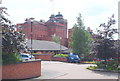
The Gates of Nottingham (11)
"Northgate - the only one of Nottingham's gates outside the old medieval city area.
Nottingham has some 15 streets incorporating the Norse-derived 'Gate', meaning a thoroughfare, not a barrier."
Next in series Image
Image: © Alan Murray-Rust
Taken: 11 Feb 2007
0.05 miles
2

The Raven
A (probably former) pub with a Homes Ales ghost sign.
Image: © David Lally
Taken: 17 Jul 2021
0.07 miles
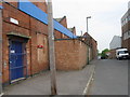
4
Bottom of Northgate
I seem to remember that the building now used by a storage company is a former bus depot. But I need to confirm this.
Image: © Mick Garratt
Taken: 29 Aug 2007
0.09 miles
6

Home Ales in Shipstone's Territory
The Raven Inn is on Rawson Street, immediately behind Shipstone's Brewery. Home Brewery, in Daybrook, was Shipstone's main rival. These painted Home Ales signs (and ones for Apollo Mineral Waters) were once a familiar sight on Home Brewery tied houses and off-licences ("beer-off" in Nottingham-speak).
Image: © John Sutton
Taken: 3 Sep 2009
0.10 miles
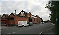
7
South-west from Duke Street
A view over some of Nottingham's western suburbs from the ridge which marks the border between Forest Fields and New Basford. Wollaton Hall is on the skyline to the left, the hills beyond Bilborough and Strelley in the centre.
Image: © John Sutton
Taken: 27 Sep 2013
0.11 miles
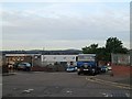
8
Nottingham, NG7 (New Basford)
The rear of the former Shipstones Star Brewery in New Basford forms a backdrop to Drayman's Court, a cul-de-sac. By 1922 Shipstones had absorbed both the Beeston Brewery Company and William Hooley Ltd and by 1939, it owned 550 licensed premises; had 30 diesel lorries for long distance deliveries and kept 50 horses for local delivery work. The brewery remained an independent family business until 1978 when it was taken over by Greenall's of Warrington. In 1990, Greenall's announced that they were ending all beer production and changing to become a "purely retailing company". Thus production ceased here in early 1991, although Shipstones branded beers continued to be brewed for some years afterwards at its breweries in Burton upon Trent.
Image: © David Hallam-Jones
Taken: 24 Jun 2012
0.12 miles
9
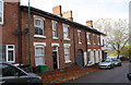
Gawthorne Street houses
Ordnance Survey records indicate that a benchmark levelled at 70.598m above Newlyn Datum was verified in 1962 on #52 at its junction with #54
Image: © Roger Templeman
Taken: 4 Nov 2017
0.13 miles
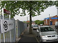
10
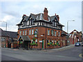
Horse and Groom, Radford Road
This was the brewery tap for the adjacent Shipstones Brewery, and the Shipstones name is still prominently displayed.
Image: © Alan Murray-Rust
Taken: 24 Jun 2008
0.14 miles